When your smartphone screen goes dark in a deep canyon or under a dense forest canopy, a dedicated handheld GPS becomes the only reliable link between you and your planned route. Unlike a phone that depends on cellular towers, these devices use satellite networks to fix your position, track your path, and guide you back to safety even where no signal exists.
I’m Mohammad Maruf — the founder and writer behind Drink4Good. I’ve spent years analyzing handheld GPS hardware, comparing satellite lock speeds, mapping quality, and battery endurance to separate the tools built for serious backcountry use from those that only look the part.
This guide focuses on the best gps for backpacking by testing real-world specs like multi-band satellite support, sunlight-readable displays, and battery life that lasts through multi-day trips without a recharge.
How To Choose The Best GPS For Backpacking
Not every handheld GPS is built for the demands of backpacking. The key factors that separate a trail-ready device from a consumer gadget revolve around satellite reception, battery endurance, map availability, and physical durability. Understanding these specs before you buy ensures you pick a unit that performs when you need it most.
Satellite Support and Positioning Accuracy
A backpacking GPS should support multiple satellite constellations—GPS, GLONASS, Galileo, and BeiDou—to maintain a lock in challenging environments like deep valleys or under heavy tree cover. The latest multi-band receivers (L1/L5) push accuracy down to about six feet, which matters when navigating off-trail or in featureless terrain.
Battery Life and Power Source
Battery life in continuous tracking mode varies from 16 hours to over 400 hours depending on the model and settings. Devices that run on standard AA batteries allow you to carry spares and never worry about a dead internal pack. Rechargeable units with USB-C ports are more convenient for shorter trips but require a power bank for extended backcountry travel.
Mapping and Navigation Features
Preloaded TopoActive maps with routable trails and roads are a baseline for serious navigation. The best units also support microSD map expansion and allow you to load custom routes from apps like AllTrails. A 3-axis compass and barometric altimeter provide critical directional and elevation data even when stationary.
Satellite Communication and Safety
If you travel solo or in remote areas, a GPS with built-in satellite messaging and SOS capability—like those using the Iridium or Globalstar networks—lets you send texts and trigger emergency response without any cell coverage. These features require a subscription plan, so factor that into your long-term budget.
Quick Comparison
On smaller screens, swipe sideways to see the full table.
| Model | Category | Best For | Key Spec | Amazon |
|---|---|---|---|---|
| Garmin GPSMAP 67i Bundle | Premium Communicator | Multi-day solo expeditions with SOS | 425 hr battery, Iridium 2-way | Amazon |
| Garmin GPSMAP 65 | High-Precision Navigator | Steep terrain and dense forest | Multi-band L1/L5, 2.6″ display | Amazon |
| Garmin GPSMAP 64sx | Rugged Trail GPS | Off-trail hiking with quad helix antenna | 16 hr battery, 2.6″ LCD | Amazon |
| Garmin eTrex 32x | Compact Classic | Lightweight day hikes | 25 hr battery, 2.2″ display | Amazon |
| Spot X | Satellite Messenger | Off-grid text and SOS | 240 hr standby, Globalstar | Amazon |
| Bushnell BackTrack Mini | Budget Trail Finder | Simple return-to-trailhead | 24 hr battery, Bluetooth | Amazon |
| Handheld GPS with Topo Map | Mid-Range Navigator | Hikers needing USA topo maps | 36 hr battery, 3.2″ screen | Amazon |
| A6 Handheld GPS | Entry-Level Tracker | Basic track recording and navigation | 20 hr battery, 2.4″ display | Amazon |
| ZL660 Surveying GPS | Land Measurement Tool | Property and area measurement | 48 hr battery, 3.2″ screen | Amazon |
In‑Depth Reviews
1. Garmin GPSMAP 67i Bundle
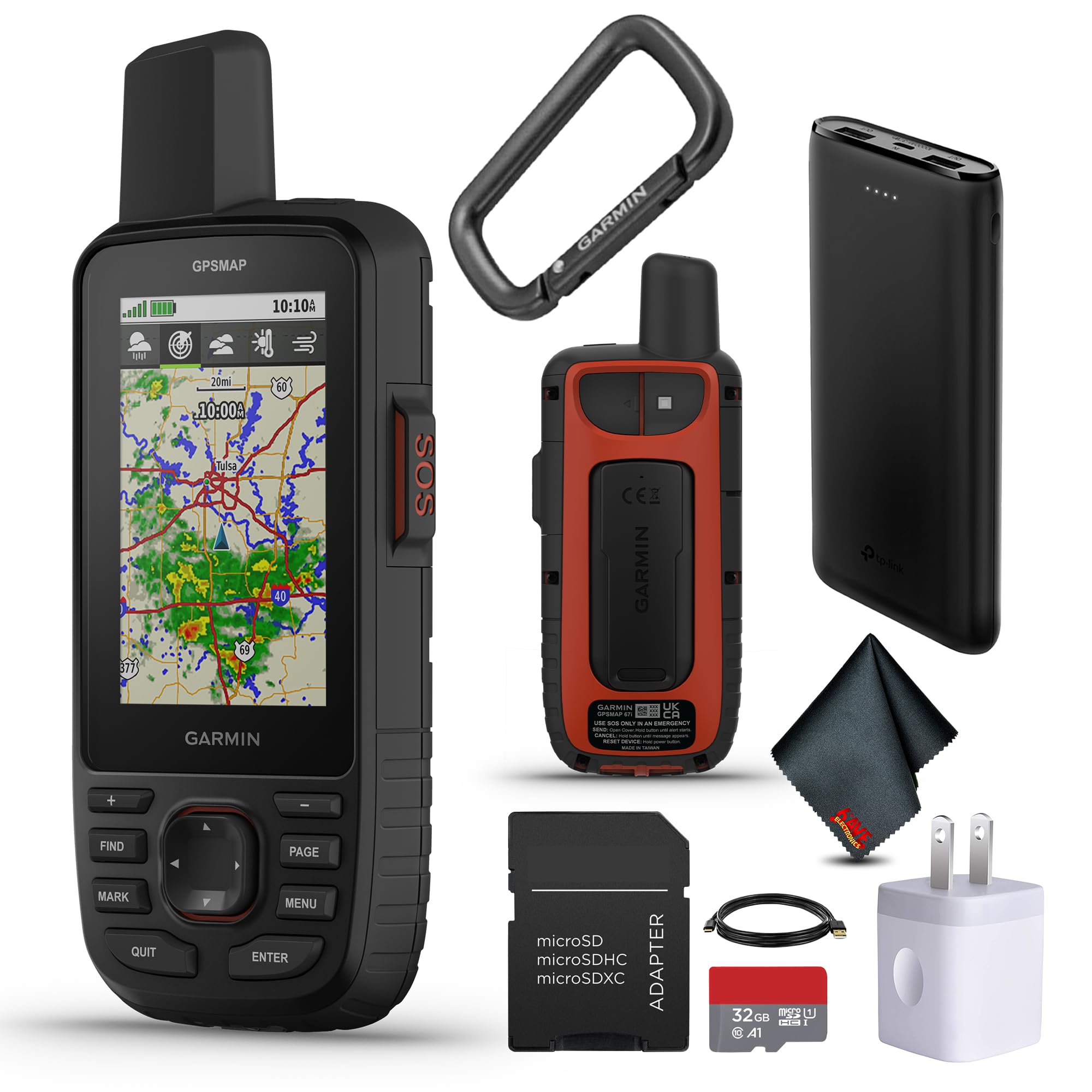
The Garmin GPSMAP 67i combines a multi-band GNSS receiver with Iridium satellite messaging, making it the most capable all-in-one device for serious backpackers. Its massive 425-hour battery life in expedition mode lets you leave the power bank at home for week-long trips, while the preloaded TopoActive maps and 3-inch sunlight-readable display deliver clear navigation in any light.
Multi-band support across GPS, Galileo, and QZSS provides precise positioning even in steep canyons and under dense tree cover—where lesser units often lose lock. The interactive SOS feature connects directly to Garmin Response, a 24/7 emergency coordination center, and two-way messaging lets you coordinate with search and rescue or check in with family without cell service.
This bundle includes a 32GB microSD card and charging accessories, so you have room for additional map downloads right out of the box. The Wi-Fi connectivity simplifies map updates, and the device also pairs with the Garmin Explore app for trip planning and waypoint syncing on your smartphone.
Why it’s great
- Multi-band GNSS with Iridium satellite messaging built in
- 425-hour battery in expedition mode covers extended trips
- Wi-Fi for direct map downloads without a computer
Good to know
- Requires an active inReach subscription for messaging and SOS
- Setup involves multiple Garmin apps for full functionality
2. Garmin GPSMAP 65

The Garmin GPSMAP 65 is designed for backpackers who need sub-meter accuracy in the most challenging environments. Its multi-band L1/L5 technology locks onto GPS, GLONASS, Galileo, and QZSS simultaneously, providing position fixes accurate to within six feet even under heavy forest canopy or in steep, rocky terrain where single-band units drift.
The 2.6-inch sunlight-readable color display with dedicated push buttons works flawlessly with gloves, wet hands, or in rain—unlike touchscreen models that become frustrating in bad weather. Preloaded TopoActive maps include routable trails and public land boundaries, and the microSD slot allows you to expand storage for custom map sets.
Battery life runs up to 16 hours in continuous tracking mode with standard AA batteries, and the unit supports the Garmin Explore app for managing tracks, routes, and waypoints on your smartphone. The rugged, IPX7 waterproof build handles full immersion, making it a reliable partner for creek crossings and unexpected downpours.
Why it’s great
- Multi-band GNSS delivers ~6ft accuracy in dense cover
- Dedicated buttons operate perfectly with gloves
- Standard AA batteries for easy field replacement
Good to know
- No satellite messaging or SOS built in
- Garmin BaseCamp software can be finicky for route planning
3. Garmin GPSMAP 64sx

The GPSMAP 64sx stands out for its quad helix antenna design, which offers superior signal reception in gullies and under tree cover compared to patch antennas found on many competitors. With multi-GNSS support covering GPS, GLONASS, and Galileo, it maintains a reliable lock even when you’re weaving through narrow slot canyons or thick pine forests.
The 2.6-inch sunlight-readable display and button-only interface make it easy to operate with gloved hands in freezing conditions. A 3-axis compass with barometric altimeter provides heading and elevation data even when stationary, and the preloaded TopoActive maps include routable trails for both hiking and mountain biking routes.
Bluetooth and ANT+ wireless connectivity allow the 64sx to pair with compatible smartphones and sensors, giving you smart notifications and the ability to sync waypoints via the Garmin Explore app. Battery life reaches 16 hours in GPS mode with two AA batteries, and the device is built to IPX7 standards for complete water protection.
Why it’s great
- Quad helix antenna outperforms patch antennas in weak signal areas
- 3-axis compass and barometric altimeter included
- Bluetooth and ANT+ for smartphone pairing
Good to know
- No multi-band frequency support like the GPSMAP 65
- Internal memory limited; microSD card recommended for additional maps
4. Garmin eTrex 32x

The eTrex 32x is a no-frills handheld that prioritizes battery life and durability over flashy extras. Running on two AA batteries, it delivers up to 25 hours in GPS mode and can stretch well beyond 50 hours when the backlight is reduced and WAAS is off. That kind of endurance makes it a practical choice for multi-day trips where charging is not an option.
The 2.2-inch sunlight-readable color display supports 240 x 320 pixels—sharp enough to read trail junctions and contour lines. GPS and GLONASS satellite support provides solid accuracy in most conditions, and the addition of a 3-axis compass and barometric altimeter (not available on the standard eTrex 22x) gives it full navigational capability for off-trail travel.
Preloaded TopoActive maps with routable roads and trails come standard, and the 8GB of internal memory plus a microSD slot leaves plenty of room for custom maps. Physical buttons mean you can operate the eTrex 32x in heavy rain or while wearing thick winter gloves without frustration.
Why it’s great
- Exceptional battery life with standard AA batteries
- Compact and lightweight for ultralight packs
- Physical buttons work in all weather conditions
Good to know
- Smaller screen size makes map detail harder to read at speed
- Screen refresh rate can feel sluggish during fast panning
5. Spot X

The Spot X is a dedicated two-way satellite messenger that fills the communication gap when you venture beyond cell range. Using the Globalstar satellite network, it lets you send and receive text messages and trigger an SOS to emergency services from virtually anywhere on the planet—no cell tower required.
Its standalone design includes a physical QWERTY keypad for typing messages, which is useful for sending detailed location updates without needing a smartphone. The device also syncs via Bluetooth with the Spot app on your phone for easier message composition and map viewing when you want a larger screen.
Battery life in standby mode reaches 240 hours, and the unit is built with a rugged plastic enclosure and a carabiner strap for easy attachment to your pack. Keep in mind that the Spot X requires an active subscription plan for messaging and SOS services, and the proprietary micro-USB charging port is less convenient than modern USB-C standards.
Why it’s great
- Two-way messaging and SOS on the Globalstar network
- Physical QWERTY keypad for typing messages
- Long standby battery life for extended trips
Good to know
- Subscription required for all satellite services
- Receiving messages can fail when near 5G cell towers
6. Bushnell BackTrack Mini

The Bushnell BackTrack Mini is a straightforward device for hikers who primarily need to mark their starting point and navigate back to it. It uses GPS to capture your trip origin and displays the direction and distance back to that waypoint, making it a practical backup for day hikes where you don’t want to constantly check a full topo map.
Its compact size fits easily in a pants pocket or on a pack strap, and the large, glove-friendly buttons make operation simple even in cold weather. Bluetooth connectivity allows you to sync trips and waypoints to the Bushnell Connect app on your smartphone for later review or sharing, and the rechargeable battery lasts up to 24 hours on a single charge.
The BackTrack Mini also shows elevation gain and loss, barometric pressure, and sunrise/sunset times. However, it lacks preloaded maps and does not offer breadcrumb trails or waypoint storage beyond a single saved location, so it is best used as a simple return-to-base tool rather than a full navigation system.
Why it’s great
- Simple one-button mark-and-return operation
- Very compact and lightweight for minimal pack weight
- Bluetooth sync with smartphone app for trip data
Good to know
- No built-in maps or breadcrumb trail tracking
- Distance readings can overestimate by up to 60 percent
7. Handheld GPS with Topo Map (NiesahYan)

This NiesahYan handheld GPS brings preloaded USA Topo maps and a large 3.2-inch sunlight-readable display to the mid-range tier, offering a full navigation experience at a lower entry price than premium Garmin models. The multi-GNSS support (GPS, Galileo, BeiDou, and QZSS) delivers accuracy within six feet, which is competitive with much more expensive units.
The 36-hour rechargeable battery provides enough power for long weekends without needing a mid-trip charge, and the IP66 water-resistant rating protects against heavy rain and splashes. Physical buttons and an anti-slip body make it easy to handle in wet conditions, and the 3-axis compass with barometric altimeter provides reliable directional and elevation data.
With 32GB of internal memory, there is ample space for downloading additional maps, and USB-C charging means you can share a cable with modern smartphones and power banks. Some users report the user manual is difficult to follow, and a small number of units have experienced boot-loop failures, so testing the device before a major trip is advisable.
Why it’s great
- Large 3.2-inch screen with excellent sunlight readability
- 32GB internal memory for extensive map storage
- USB-C charging with 36-hour battery life
Good to know
- Manual and online instructions are not beginner-friendly
- Quality control issues reported with boot failures on first use
8. A6 Handheld GPS (NiesahYan)

The A6 is a functional handheld GPS that focuses on the essentials: track recording, waypoint storage, and return-to-start navigation. It supports four satellite systems (GPS, Galileo, BeiDou, and QZSS) for reliable positioning, and the 2.4-inch sunlight-readable color display makes it easy to read your coordinates and track data in bright conditions.
Its rechargeable battery delivers up to 20 hours of continuous use, and the compact, rugged shell fits comfortably in one hand. The device includes a built-in GPS compass for heading information, a barometric altimeter for elevation readings, and sunrise/sunset times—a surprising depth of features for the entry-level price point.
It is important to note that the A6 does not include any preloaded maps. It functions as a coordinate tracker and breadcrumb navigator, showing your position as latitude and longitude rather than on a topo background. Buyers expecting a map-based interface will be disappointed, but for hikers who work confidently with coordinates, it offers accurate tracking and reliable route memory.
Why it’s great
- Fast satellite lock with four GNSS constellations
- Very compact and lightweight design
- Includes barometric altimeter and compass
Good to know
- No preloaded maps—coordinate-based navigation only
- Steep learning curve for users new to coordinate navigation
9. ZL660 Land Surveying GPS (YuisyNie)
The ZL660 is a specialized handheld GPS designed for land measurement rather than general trail navigation, making it a niche tool for backpackers who need to assess property boundaries, pasture areas, or garden plots while in the field. It supports six satellite systems and delivers area accuracy within 0.002 acres and distance accuracy within five feet.
Seven dedicated one-button measurement modes cover land area, straight distance, curved distance, height, slope, and coordinate saving. The 3.2-inch sunlight-readable screen provides clear visibility even in direct noon sun, and the 4000mAh battery runs for 48 hours—enough for several full days of surveying work without recharging.
The rugged, waterproof body and ergonomic grip make it suitable for outdoor use, but the device lacks general navigation features like breadcrumb trails, map displays, or routing. It is best considered a specialized companion for backpackers who also need to measure terrain features, rather than a primary navigation tool for backcountry travel.
Why it’s great
- Highly accurate area and distance measurement for land assessment
- 48-hour battery life for extended fieldwork
- 7 dedicated measurement modes with one-key operation
Good to know
- Not designed for trail navigation or map display
- Accuracy drops significantly on areas smaller than half an acre
FAQ
Can I use my smartphone instead of a dedicated GPS for backpacking?
What is the difference between GPS and inReach satellite messaging?
How often should I replace the batteries in an AA-powered GPS?
Do I need a subscription for satellite messaging on a GPS communicator?
Final Thoughts: The Verdict
For most users, the gps for backpacking winner is the Garmin GPSMAP 67i Bundle because it combines multi-band positioning accuracy with Iridium satellite messaging, push-button navigation, and battery life that lasts weeks in expedition mode. If you want a more budget-friendly unit with precise multi-band tracking and do not need satellite communication, grab the Garmin GPSMAP 65. And for a compact, lightweight backup with phenomenal battery runtimes on standard AA batteries, nothing beats the Garmin eTrex 32x.