Paddling a remote river or lake chain means committing to a route where a wrong turn can add miles of extra work or push you into dangerous water. A dedicated GPS unit removes the guesswork from your trip, letting you focus on reading the current and enjoying the scenery instead of constantly checking a paper map that might be outdated or waterlogged.
I’m Mohammad Maruf — the founder and writer behind Drink4Good. I’ve spent hundreds of hours analyzing satellite communication specs, battery endurance tests, and mapping software to separate the gear that genuinely saves a trip from the gadgets that just add weight to your dry bag.
After weighing waterproofing ratings, battery life, and mapping capabilities against real paddling scenarios, I’ve built a focused list of the best gps for canoeing that balances safety features with practical navigation tools for expedition paddlers.
How To Choose The Best GPS For Canoeing
Canoeing trips span lazy afternoon floats to multi-day wilderness expeditions. The right GPS unit for your trip depends on how far from cell towers you plan to paddle and whether your primary need is navigation or emergency communication. Below are the key factors to weigh before you buy.
Waterproofing and Buoyancy
A canoe is a wet environment. Splashes, rain, and the occasional capsize mean your GPS must survive full immersion. Look for an IPX7 rating (submersible to 1 meter for 30 minutes) or better. If you paddle whitewater or open crossings, a buoyant device like the ACR ResQLink View adds an extra layer of security — it floats if you drop it in the drink.
Battery Life and Power Source
A long day on the water can easily stretch to 10 or 12 hours, and multi-day trips mean you cannot rely on a wall outlet. Devices with AA batteries (like the Garmin GPSMAP series) let you carry spares in your dry bag. Rechargeable units with USB-C, like the NiesahYan models, are lighter but require a power bank for extended trips. Always look for a rated battery life of at least 16 hours in standard GPS mode.
Maps and Navigation Data
Some handheld units come preloaded with TopoActive maps showing roads, trails, and waterways. Others only display a coordinate grid and compass heading. For canoeing, preloaded topo maps with water features are extremely useful. If a unit has no built-in maps, you will need to bring a separate paper chart or phone as backup unless you are comfortable navigating purely by waypoint and bearing.
Satellite Communication vs. Navigation
There are two distinct categories here. Handheld navigators (Garmin GPSMAP, Bushnell BackTrack) show you where you are and how to return to camp. Satellite messengers and PLBs (Spot Gen4, ACR ResQLink) let you send an SOS or check in with family but do not provide turn-by-turn navigation. For remote Canadian Shield routes, you likely need both: a navigation unit to find your way and a beacon to call for help if something goes wrong.
Subscription Requirements
Satellite messengers like the Spot Gen4 require an active monthly or annual subscription plan to send messages. Personal locator beacons (PLBs) like the ACR ResQLink require no subscription — you only register the device with national authorities. If you only paddle a few weeks per year, a subscription-free PLB may be more cost-effective. If you want to send periodic “I’m OK” texts to family, a messenger with a flexible plan is worth the recurring cost.
Quick Comparison
On smaller screens, swipe sideways to see the full table.
| Model | Category | Best For | Key Spec | Amazon |
|---|---|---|---|---|
| Garmin GPSMAP 65s | Handheld Navigator | Multi-band accuracy & AA power | Multi-band GNSS + multi-GNSS | Amazon |
| ACR ResQLink View | PLB | No-subscription emergency beacon | 406 MHz + buoyant chassis | Amazon |
| Garmin GPSMAP 64sx | Handheld Navigator | Quad-helix antenna & durability | Preloaded TopoActive maps | Amazon |
| ACR ResQLink 400 | PLB | Compact global rescue beacon | GPS + Galileo GNSS | Amazon |
| NiesahYan (3.2″ screen) | Handheld Navigator | Large screen & USA topo maps | 36-hour battery life | Amazon |
| Nautilus LifeLine nexGen | Marine Rescue | AIS/DSC alert for coastal waters | 425 ft waterproof depth rating | Amazon |
| Bushnell BackTrack Mini | Mini Navigator | Ultra-compact waypoint return | 35-hour battery life | Amazon |
| Spot Gen 4 | Satellite Messenger | Satellite check-in & SOS | Globalstar satellite network | Amazon |
| NiesahYan A6 | Budget Navigator | Entry-level coordinate tracker | Multi-GNSS support | Amazon |
In‑Depth Reviews
1. Garmin GPSMAP 65s

The Garmin GPSMAP 65s is the most fully featured handheld navigator on this list, combining multi-band frequency support with multi-GNSS (GPS, GLONASS, Galileo, QZSS) to lock onto satellites in steep river gorges and under dense riparian canopy. Its 2.6-inch sunlight-readable color display and physical button layout make it easy to operate with wet hands or gloves, and the preloaded TopoActive maps show water features and portage trails for US paddlers.
Battery life varies by usage — in Battery Save mode with GPS only, you can get over 27 hours from a set of AA NiMH cells, which is critical for multi-day canoe trips where recharging is impossible. The 3-axis compass and barometric altimeter provide accurate heading and elevation data even when you are stationary, and the device is compatible with the Garmin Explore app for managing routes and waypoints on your smartphone. Reviewers consistently praise its positional accuracy of roughly six feet.
The device runs on standard AA batteries, so you can carry spares in a dry bag and swap them in seconds without hunting for a USB port. Some users note that Garmin’s BaseCamp software has a steep learning curve and that the default map detail is low, but third-party topographic maps can be loaded via microSD to fill in the gaps. For paddlers who want a rugged, accurate, and reliable navigation tool, this is the gold standard.
Why it’s great
- Multi-band technology delivers superior accuracy
- AA batteries are user-replaceable on the water
- Physical buttons work in all weather
Good to know
- Garmin software requires time to master
- Default map detail is basic out of the box
2. ACR ResQLink View

The ACR ResQLink View is a Category 1 personal locator beacon that floats, which is a major advantage for canoeists who risk dropping gear in deep water. When activated, it sends a 406 MHz distress signal with your GPS coordinates directly to search and rescue agencies via the COSPAS-SARSAT satellite network — no subscription required, just a one-time registration with NOAA. It also emits a 121.5 MHz homing signal plus a bright LED strobe and an infrared strobe for night visibility.
This PLB transmits at 5 watts of power, compared to the sub-0.5 watt output of satellite messengers, which means its signal penetrates tree cover and reaches satellites much more reliably in an emergency. The unit is small enough to clip to a PFD oral inflation tube or belt, and it includes multiple attachment options. The internal battery is non-replaceable but has a five-year shelf life, and the unit performs a self-test so you can verify it works before each trip.
The key trade-off is that the ResQLink View is purely an emergency beacon — it does not provide navigation, track recording, or two-way messaging. For paddlers who travel in groups or carry a separate GPS navigator, that is fine. The optional 406Link subscription adds the ability to send non-emergency GPS test messages via SMS, but that is not required for the core rescue function. This is the device you hope you never use but would be lost without on a remote waterway.
Why it’s great
- Floats if dropped overboard
- No monthly subscription fees
- High 5W transmission power
Good to know
- No navigation or map features
- Internal battery is sealed and non-replaceable
3. Garmin GPSMAP 64sx

The Garmin GPSMAP 64sx is a proven workhorse with a quad-helix antenna that provides superior satellite reception compared to the patch antennas found in many budget handhelds. It supports multi-GNSS (GPS, GLONASS, and Galileo) and comes preloaded with TopoActive maps covering US and Australia, showing routable roads, trails, and waterways that are highly useful for planning canoe portages and identifying access points.
The 2.6-inch sunlight-readable color display is paired with a button-operated interface that works reliably in rain and with wet paddling gloves. The 3-axis compass with barometric altimeter provides accurate heading and elevation data even when stationary, and Bluetooth and ANT+ wireless connectivity allow you to pair with a compatible smartphone for smart notifications and data sharing. Battery life is rated at up to 16 hours in GPS mode, and the device runs on two AA batteries.
One limitation noted by users is the internal memory — it is somewhat small for storing large map tiles, and Garmin does not include a microSD card in the box. You will need to add your own card to load detailed custom maps. Reviewers also mention that the manual is not pre-installed on the device, so you must download it separately. Despite these quirks, the 64sx remains a favorite for its rock-solid antenna performance and durable build quality in wet conditions.
Why it’s great
- Quad-helix antenna locks satellites quickly
- Preloaded TopoActive maps for US waterways
- Rugged, water-resistant build
Good to know
- Limited internal memory for map storage
- Manual must be downloaded separately
4. ACR ResQLink 400
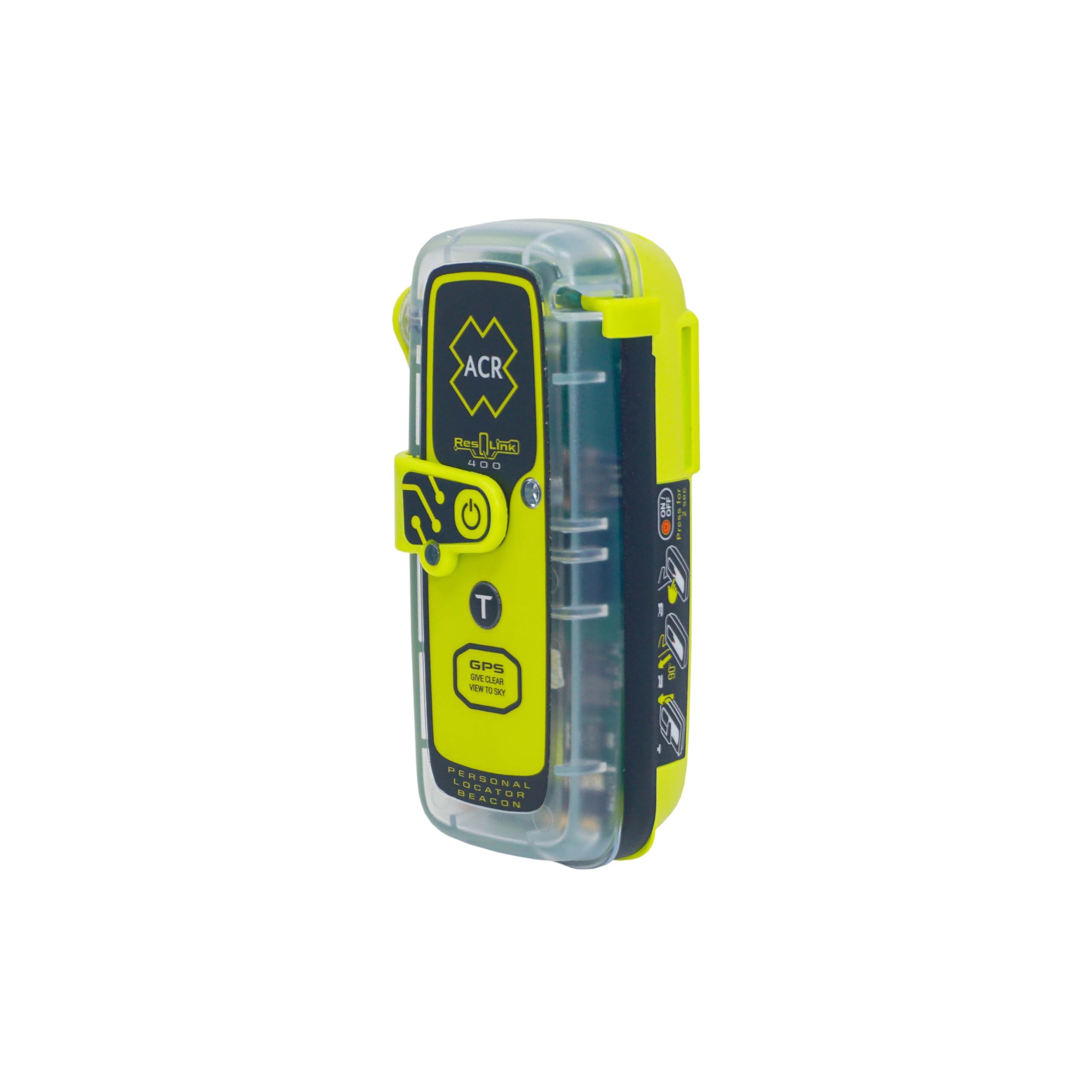
The ACR ResQLink 400 is a compact subscription-free personal locator beacon that uses both GPS and Galileo GNSS constellations to transmit your precise location to search and rescue forces worldwide. It is a Category 1 PLB that operates on the 406 MHz distress frequency with a 121.5 MHz homing beacon, and it includes a bright LED strobe and infrared strobe for night-time visibility. The rugged chassis is rated as waterproof and is depth-rated for submersion, making it suitable for capsizing scenarios.
Weighing only 0.33 pounds, the ResQLink 400 is light enough to attach to a PFD without creating drag, and it comes with a belt clip, oral inflation tube clip, and attachment strap. The internal battery is user-replaceable (unlike the ResQLink View), which extends the usable life of the device beyond a single battery cycle. Annual self-test functionality lets you verify the unit is operational before every trip without incurring charges.
The primary limitation is the same as all PLBs — it does not provide navigation, waypoint recording, or two-way communication. It is purely a rescue device. For paddlers who paddle in groups where one person carries a navigation unit and another carries the beacon, this is an efficient split. Reviewers who fish solo in the Gulf or paddle remote coastlines consistently rate it as essential gear, noting that the peace of mind is worth the upfront investment.
Why it’s great
- No ongoing subscription fees
- User-replaceable battery extends device life
- Compact and lightweight for PFD mounting
Good to know
- No navigation or mapping capabilities
- Annual self-test must be done manually
5. NiesahYan Handheld GPS (3.2″ Screen)

The NiesahYan handheld GPS with a 3.2-inch sunlight-readable screen stands out for its massive 36-hour battery life on a single charge, which is more than enough for a long weekend canoe trip without needing a power bank. It comes preloaded with USA Topo maps and has 32 GB of internal memory for storing additional map data. The device supports multi-GNSS (GPS, Galileo, BeiDou, QZSS) and delivers location precision within six feet.
The IP66 water-resistant rating means it can handle heavy rain and splashes, though it is not designed for submersion like the Garmin units. The combination of push-button and touch controls gives you flexibility, though the touchscreen may be less responsive with wet fingers. The 3-axis compass and barometric altimeter provide accurate heading and elevation data, and the track navigation feature lets you record your route and guide back to your starting point.
Some users report reliability concerns, including a boot-loop issue after a single field test, and the instructions are noted as being difficult to follow. The device also does not support microSD expansion, so you are limited to the 32 GB of internal storage. For paddlers who prioritize long battery life and a large, readable screen for route planning at camp, this device offers strong value — just ensure you test it thoroughly before a remote trip.
Why it’s great
- 36-hour battery life for multi-day trips
- Large 3.2″ sunlight-readable screen
- Preloaded USA Topo maps with 32 GB memory
Good to know
- Reports of reliability issues from some units
- Water-resistant, not fully submersible
6. Nautilus LifeLine Marine Rescue GPS nexGen

The Nautilus LifeLine nexGen is a specialized marine rescue GPS that uses VHF radio waves to send AIS (Automatic Identification System) and DSC (Digital Selective Calling) distress alerts directly to nearby vessels. Unlike a PLB that alerts satellite-based rescue coordination centers, this device alerts boats in your immediate vicinity — critical if you capsize in a busy shipping channel or coastal paddling zone. It is depth-rated to 425 feet with the outer lid closed, making it suitable for scuba divers as well as paddlers.
The unit is compact and weighs only 4.6 ounces with batteries installed. It works worldwide via the Globalstar satellite network for position calculation, but the alert function relies on VHF radio waves, so you need to be within range of AIS-equipped or DSC-equipped boats. The GPS position is accurate to 1 meter, and the device can send a “Distress Alert” for emergencies or a “Position Advisory” for non-emergency situations. It is IP68 watertight even with the cap open.
This is a niche device best suited for sea kayaking or canoeing in coastal waters where boat traffic is present. It is less useful on inland lakes or river systems where few AIS-equipped vessels operate. The device requires two CR123A photo batteries (not included), and some users note that the deployment tool for the antenna is easy to lose and has no storage slot on the unit. If you paddle near shipping lanes, this beacon fills a gap that satellite-based PLBs cannot match.
Why it’s great
- Alerts nearby AIS/DSC-equipped vessels
- Extreme depth rating of 425 feet
- IP68 watertight with cap open
Good to know
- Only effective in areas with AIS/DSC boat traffic
- Antenna deployment tool is easy to misplace
7. Bushnell BackTrack Mini GPS

The Bushnell BackTrack Mini is a compact, ultra-portable GPS designed for a single primary function: capturing a waypoint (like your put-in or camp) and guiding you back to it. It is not a full-featured navigator with topographic maps — instead, it displays a simple arrow pointing toward your saved location along with distance, elevation gain/loss, and barometric pressure. For a day paddle on a familiar river where you just want a backup for finding the takeout, this device gets the job done with minimal fuss.
Battery life is rated at up to 35 hours on a full charge, and the device uses a rechargeable battery charged via Micro USB. The display is easy to read, and the large buttons are glove-friendly — important for cold-weather paddling. Bluetooth connectivity lets you sync trips and waypoints to the Bushnell Connect app on your smartphone for sharing or storage. The unit also shows sunrise, sunset, moonrise, and moonset times, which is helpful for planning paddle timing.
The BackTrack Mini has several notable limitations. The companion app has been reported to stop working properly on some Android phones, and the Micro USB charging port is finicky and hard to plug in securely. Some reviewers note that the distance readings can overestimate actual traveled distance by up to 60 percent, and elevation readings may be off by 200 feet or more. For basic waypoint return in open terrain, this device is adequate, but it lacks the precision and mapping depth that serious expedition paddlers need.
Why it’s great
- Very compact and lightweight
- Long 35-hour battery life
- Glove-friendly buttons and simple interface
Good to know
- App reliability issues on some devices
- Distance and elevation accuracy concerns
8. Spot Gen 4 Satellite GPS Messenger

The Spot Gen 4 is a dedicated satellite messenger that lets you send check-in messages and SOS alerts from beyond cell tower range using the Globalstar satellite network. It is not a navigation device — there is no map display, compass, or altimeter — but it performs its communication function reliably. The magnetic SOS and HELP buttons are designed to be easy to activate in an emergency, and the tracking feature can transmit your location at regular intervals so family can follow your progress online.
Battery life is excellent, with the device running for weeks on four AAA batteries in tracking mode. The Gen 4 is smaller than previous generations and includes a carabiner for easy attachment to a PFD or dry bag. It requires an active subscription, but the Flex plan offers seasonal pricing so you only pay when you are actively paddling. Users consistently report fast, reliable message transmission, and the device is valued at roughly half the cost of a PLB.
The Gen 4 has some ergonomic downsides. The USB cable is Micro USB (not USB-C), and changing batteries or accessing the ESN requires removing four screws, which is inconvenient in the field. The weather seal around the battery compartment can fall out, and the device does not support USB power for vehicle or camp use. For paddlers who want to text family from the river and have an SOS backup without buying a full PLB, this is a cost-effective solution — just be aware of the subscription requirement.
Why it’s great
- Reliable satellite check-in and SOS
- Long battery life on AAA batteries
- Flex plan offers seasonal subscription options
Good to know
- Requires an active subscription plan
- Battery access requires removing screws
9. NiesahYan A6 Handheld GPS

The NiesahYan A6 is a budget-friendly handheld GPS that provides multi-GNSS support (GPS, Galileo, BeiDou, QZSS) and a 2.4-inch sunlight-readable color screen. It is compact, lightweight, and equipped with essential tools like a GPS compass, barometric altimeter, and sunrise/sunset times. The rechargeable battery offers up to 20 hours of continuous use and charges via USB-C, which is a modern convenience absent from some pricier competitors.
The A6 is designed for track navigation: you record your route before heading out, and the device can guide you back to your starting position if you lose your way. The interface uses push-button controls that work with gloves, and the rugged case feels solid for its weight class. For a flatwater paddle on a straightforward lake or slow-moving river where you just need a coordinate backup, this unit provides basic functionality at a low entry cost.
The biggest limitation is that the A6 has no built-in maps whatsoever — it displays coordinates, compass heading, and elevation but not waterways, trails, or terrain. You need to bring a separate paper map or rely on a smartphone for context. Some reviewers report accuracy issues on steep, winding trails, and the lack of map support makes the device impractical for navigation on complex river systems. For canoeists who want a simple coordinate tracker for emergency waypoint recall and nothing more, the A6 works — but serious paddlers will quickly outgrow it.
Why it’s great
- USB-C charging is convenient
- Compact and lightweight for its price tier
- Multi-GNSS support improves lock speed
Good to know
- No built-in topographic maps
- Accuracy drops on winding or steep terrain
FAQ
Do I really need a dedicated GPS if I have a smartphone with offline maps?
What is the difference between a satellite messenger and a personal locator beacon?
How does tree cover on a river affect GPS accuracy?
Can I use a marine GPS designed for powerboats for canoeing?
What battery type lasts longest for multi-day canoe trips?
Final Thoughts: The Verdict
For most users, the best gps for canoeing winner is the Garmin GPSMAP 65s because it combines multi-band satellite accuracy with user-replaceable AA batteries and a rugged, waterproof chassis that can handle capsizes and rain. If you want a subscription-free emergency beacon that floats and will summon rescue from anywhere in the world, grab the ACR ResQLink View. And for paddlers who need satellite check-in capability on a budget, the Spot Gen 4 provides reliable SOS and messaging at a lower upfront cost than a PLB.