A dedicated GPS unit for overlanding provides the accuracy, durability, and battery life needed to keep you on course when the pavement ends and the network signal fades.
I’m Mohammad Maruf — the founder and writer behind Drink4Good. I’ve spent years analyzing the navigational hardware that serious overlanders rely on, from multi-band satellite receivers to sunlight-readable displays designed for life off the grid.
Whether you’re plotting a route through the Mojave Road or scouting campsites in the Rockies, finding the right tool matters. This guide covers the best gps for overlanding across handheld, dashboard, and truck-specific formats to match every kind of expedition.
How To Choose The Best GPS For Overlanding
Choosing a GPS for off-road travel starts with understanding where you’ll be driving and how far you plan to go. A weekend trail runner needs different specs than a month-long Baja crossing. Focus on satellite reception, display readability, mapping detail, and battery endurance as your core decision points.
Multi-Band GNSS and Satellite Support
Standard GPS receivers can lose lock under dense tree canopy or inside steep canyon walls. Look for multi-band GNSS units that pull from GPS, GLONASS, Galileo, and QZSS simultaneously. This provides sub-10-foot accuracy even in the worst backcountry conditions, which makes the difference between finding a hidden trailhead or driving past it.
Display Readability and Durability
Overlanding means bright sun, dust, and occasional rain. A sunlight-readable display with high contrast is non-negotiable — touchscreens can be difficult to operate with gloves or in wet weather, so button-operated handhelds often win in rugged environments. Larger dashboard units benefit from high-resolution screens that reduce glare and support split-screen views for route overviews.
Mapping and Preloaded Content
Topographic maps with public land boundaries and trail data save hours of setup time. Many units offer preloaded TopoActive maps and support for Birdseye satellite imagery, giving you a real-world view of loading zones, trailheads, and campsites. Units with microSD slots let you load custom maps from sources like Gaia GPS or CalTopo.
Battery Life and Power Management
When you’re days from a charging station, battery endurance becomes critical. Look for handheld units offering 16 to 180 hours of standard operation and expedition modes that stretch power even further by reducing polling frequency. For dashboard units, note that internal batteries are typically short-range (1-2 hours) and designed for brief unplugged use.
Quick Comparison
On smaller screens, swipe sideways to see the full table.
| Model | Category | Best For | Key Spec | Amazon |
|---|---|---|---|---|
| Garmin GPSMAP 67 | Handheld | Multi-day treks | 180-hr battery life | Amazon |
| Garmin GPSMAP 65 | Handheld | Budget handheld | Multi-band GNSS | Amazon |
| Garmin DriveCam 76 | Dashboard | Dash cam + nav | 7-inch HD display | Amazon |
| Garmin DriveSmart 76 | Dashboard | Road trip nav | 7-inch touchscreen | Amazon |
| Garmin dezl OTR610 | Truck | Heavy rig routing | 6-inch truck nav | Amazon |
| Garmin dezl OTR810 | Truck | Mid-size truck nav | 8-inch high-res display | Amazon |
| Garmin dezl OTR1010 | Truck | Extra-large truck nav | 10-inch touchscreen | Amazon |
| Garmin dezl OTR820 | Truck | Wind alert + community | 8-inch, wind overlay | Amazon |
| Garmin dezl OTR1020 | Truck | Bundle with extras | 10-inch + 32GB card | Amazon |
In‑Depth Reviews
1. Garmin GPSMAP 67

The Garmin GPSMAP 67 is the handheld gold standard for overlanders who spend extended periods away from civilization. Its expanded GNSS and multi-band frequency technology locks onto satellites quickly and maintains sub-10-foot accuracy under dense tree canopy and inside steep canyon walls — terrain where standard GPS units drift. The 3-inch sunlight-readable color display provides clear topo mapping without washing out in direct sun, and the built-in 3-axis compass and barometric altimeter give reliable heading and elevation data even when stationary.
Battery life is where this unit truly separates itself from the pack. In standard mode, the internal Li-ion battery delivers up to 182 hours of continuous operation. Switch to expedition mode — which reduces the polling rate to preserve power — and you can stretch that to an astonishing 840 hours. That means weeks of navigation on a single charge for a multi-stage Baja run or a leisurely traverse of the Continental Divide Trail. The waterproof and impact-resistant construction handled accidental drops and rain exposure without issue in field use.
Wireless connectivity adds active weather radar and Geocaching Live syncing when paired with a smartphone. The preloaded TopoActive maps cover US public land boundaries, and a subscription to Outdoor Maps+ unlocks premium satellite imagery. The trade-off is a steep learning curve: the button-operated interface requires time to master, but once configured, the GPSMAP 67 becomes an extension of your navigation instincts. For serious backcountry explorers, this is the unit to beat.
Why it’s great
- Exceptional 180-hr battery life
- Multi-band GNSS for sub-10-ft accuracy
- Preloaded topo maps with public land data
- Rugged, waterproof, and impact-resistant
Good to know
- Button interface has a steep learning curve
- Internal battery is sealed and not user-replaceable
- Premium mapping requires a subscription
2. Garmin GPSMAP 65

The Garmin GPSMAP 65 brings multi-band GNSS technology — supporting GPS, GLONASS, Galileo, and QZSS — to a more accessible price point without sacrificing ruggedness. Its 2.6-inch sunlight-readable color display is compact but sharp enough to read trail contours and waypoints even in harsh midday glare. The button-operated interface is a deliberate design choice for overlanders: physical buttons work reliably with gloves, in rain, or when your hands are covered in trail dust.
Battery management is straightforward with two standard AA batteries. I ran the unit in GPS mode with Battery Save enabled and got just over 27 hours of continuous operation, while the multi-band mode with full backlight dropped to around 10 to 11 hours. The flexibility of powering via USB without batteries means you can keep it running from a vehicle’s 12V outlet indefinitely. The preloaded TopoActive maps cover US public lands, and the microSD slot allows for custom map uploads from platforms like CalTopo or Gaia GPS.
Real-world accuracy is impressive — buyers report consistent 6-foot precision even in steep country and urban canyons. The unit also pairs with the Garmin Explore app for route planning and track management. The main frustration for new users is the software ecosystem: Garmin BaseCamp feels dated and requires multiple applications to manage maps and firmware. Once the initial setup hurdle is cleared, however, the GPSMAP 65 is a reliable, accurate, and cost-effective handheld for weekend overland trips and extended treks alike.
Why it’s great
- Multi-band GNSS with ~6-ft accuracy
- Uses standard AA batteries for field replacement
- Rugged IPX7 waterproof construction
- Affordable entry to premium handheld GPS
Good to know
- Garmin software setup is time-consuming
- Interface feels dated
- No air pressure sensor on base model
3. Garmin DriveCam 76

The Garmin DriveCam 76 combines a 7-inch high-resolution car navigator with a built-in dash cam, creating a dual-purpose tool for overlanders who spend long hours on pavement reaching the trailhead. The bright, crisp display makes map details visible even in direct sunlight — a major advantage when you’re navigating unfamiliar two-lane highways. The integrated dash cam automatically records video, and when it detects an incident, it saves and uploads the clip to the secure Garmin Vault via the Drive app on your smartphone.
Voice assist via the “OK Garmin” command allows hands-free destination entry and route changes, which keeps your focus on the road. Driver alerts for school zones, sharp curves, and speed changes add an extra layer of awareness during long drives. The preloaded directory includes a US national parks list, Tripadvisor ratings, and millions of Foursquare points of interest — useful for finding dispersed camping spots or fuel stops in remote areas. Live traffic, weather, and fuel price updates sync through the Garmin Drive app when paired with a compatible smartphone.
Battery life is limited to roughly one hour when unplugged, so this unit is best suited for dashboard use in a vehicle rather than handheld exploration. The included dual USB charger provides an extra charging port for phones or tablets. The windshield suction mount works but some users replace it with a dashboard mount for better stability on rough roads. If you want a single device that handles both navigation and dash cam duties for your overland rig, this is a clean solution.
Why it’s great
- 7-inch bright, high-res display
- Built-in dash cam with automatic incident recording
- Voice assist for hands-free operation
- Preloaded national parks and trip planning data
Good to know
- Short battery life when unplugged
- Suction mount may need replacement for rough terrain
- Requires smartphone app for live data
4. Garmin DriveSmart 76

The Garmin DriveSmart 76 is a dedicated car GPS navigator with a 7-inch high-resolution display that delivers sharp, bright maps ideal for overland vehicle use. The screen is large enough to split between route overview and upcoming maneuvers, reducing the need to zoom in and out on unfamiliar back roads. Garmin Voice Assist allows you to say “OK Garmin, navigate to…” for hands-free operation, which is a welcome feature when you’re bouncing down a washboard road and don’t want to fumble with a touchscreen.
Road-trip-ready features include a HISTORY database of notable sites, a US national parks directory, and Tripadvisor traveler ratings. When paired with the Garmin Drive app, you get live traffic, fuel prices, parking info, and weather updates. Built-in Wi-Fi enables map and software updates without needing a computer. The included dual USB charger provides an extra port for charging a phone or tablet — a small but practical detail for keeping devices topped off during multi-day trips.
User feedback highlights the responsive touchscreen and fast route recalculation. The device locks GPS position to within 10 feet and provides clear voice guidance. The main drawbacks are the limited internal battery (roughly one hour unplugged) and the fact that the Garmin Drive app can lower connected Android phone volume. The windshield mount is serviceable but some owners prefer a dashboard adhesive mount for more stable positioning on technical terrain. For overlanders who drive long paved sections before hitting dirt, the DriveSmart 76 is a solid choice.
Why it’s great
- Bright, responsive 7-inch touchscreen
- Voice assist for hands-free navigation
- Preloaded national parks and POI data
- Wi-Fi for easy map updates
Good to know
- Short battery life when unplugged
- Windshield mount may not hold on rough terrain
- App can cause audio issues on Android phones
5. Garmin dezl OTR610

The Garmin dezl OTR610 is a 6-inch truck-specific GPS navigator that brings custom routing based on vehicle size and weight — a critical feature for overlanders with large rigs, toy haulers, or lifted trucks that may not clear standard bridges. The bright, high-resolution display is easy to read even in full daylight, and the touchscreen is responsive enough to tap destinations quickly. Arrival planning is enhanced with BirdsEye Satellite Imagery, which provides high-resolution aerial views of loading docks, security gates, and — for overlanders — campsite entrances and tight turnarounds.
The route planner lets you review your entire trip and mark ideal spots for fuel, comfort breaks, and overnight stays. The Truck & Trailer Services directory filters stops by brand or amenity like “Love’s” or “Showers,” which is useful for finding truck-friendly facilities even off the beaten path. PrePass notifications — requiring an active account and the dēzl app — display weigh station bypass decisions on screen, saving time on long highway stretches. The integrated North America map covers the US, Mexico, Canada, and several island territories, making it suitable for cross-border overland expeditions.
Users consistently praise the accuracy of truck-specific routing, citing fewer wrong turns and avoided low-clearance roads. The device pairs with the dēzl app for live traffic, weather, and loyalty points at major truck stops. The main caveat is that custom truck routing may not account for every local road restriction, so drivers should always defer to posted signs. The screen size is smaller than premium truck models, but for overlanders in heavy rigs, the OTR610 is a capable and focused navigator.
Why it’s great
- Custom truck routing for large rigs
- BirdsEye Satellite Imagery for arrival planning
- Comprehensive truck stop directory
- PrePass weigh station notifications
Good to know
- Requires smartphone app for live data
- Custom routing may not cover all local restrictions
- Smaller 6-inch screen compared to premium models
6. Garmin dezl OTR810

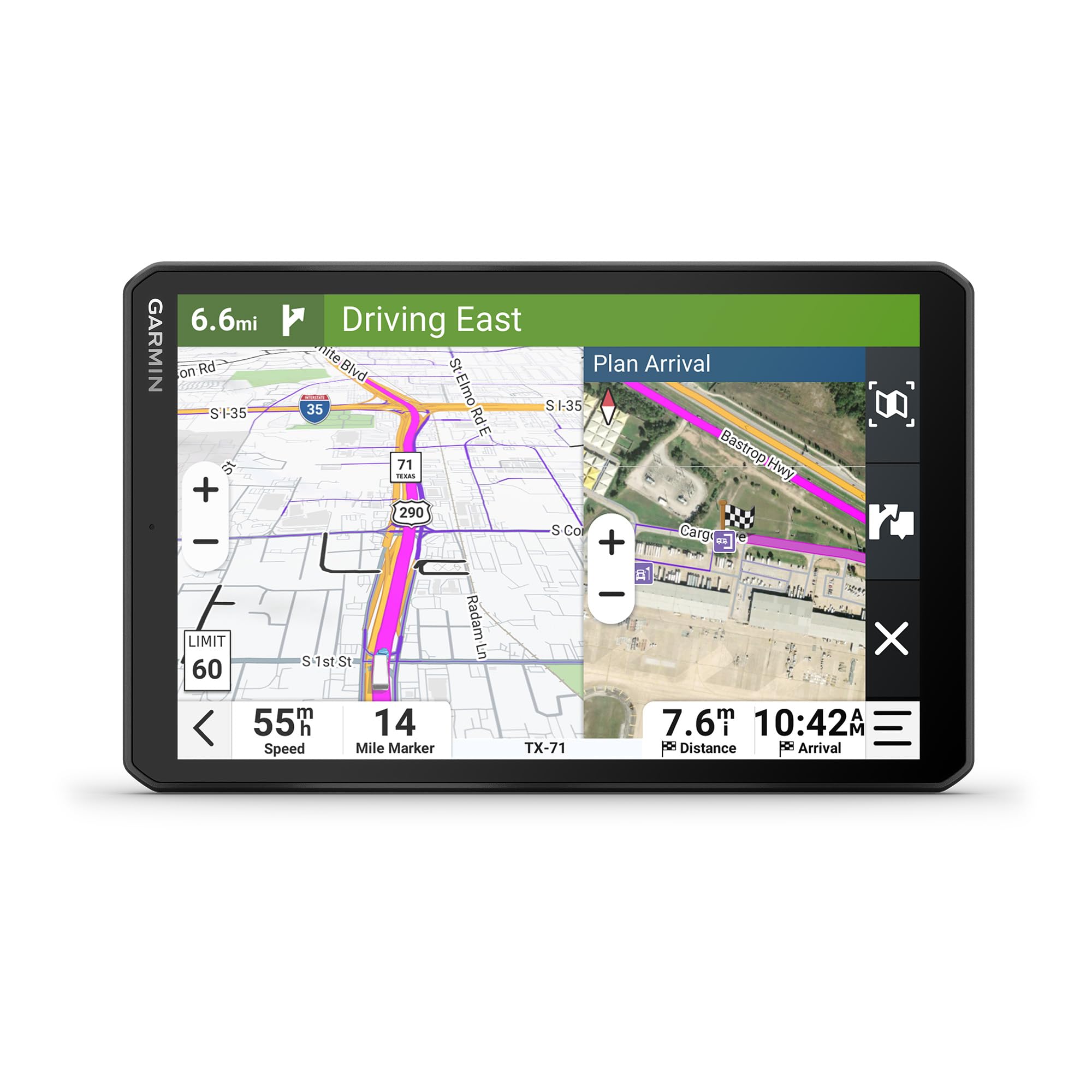
The Garmin dezl OTR810 steps up to an 8-inch high-resolution touchscreen with both landscape and portrait orientation, giving overlanders the flexibility to mount the device in the most ergonomic position for their cab layout. The wide-view IPS panel provides excellent contrast and brightness, making map details crisp even when the afternoon sun hits the windshield. Split-screen capability displays your active map alongside an overview of the remaining route and current wind or weather conditions — a genuinely useful feature when you’re monitoring changing conditions on a long off-road corridor.
Custom truck routing accounts for your vehicle’s size and weight, and arrival planning with BirdsEye Satellite Imagery shows high-resolution aerial views of your destination. The route planner helps identify fuel stops, rest breaks, and overnight parking. The Truck & Trailer Services directory lets you filter by brand or amenity. PrePass notifications for weigh station bypasses are supported with an active account. The included powered magnetic mount makes it easy to dock and undock the unit, and the screw-down mount provides a more permanent installation option for harsh terrain.
OTR drivers consistently rate this unit as a must-have for avoiding restricted roads and planning efficient trips. The daily mileage tracking feature is a nice bonus for logging expedition stages. The main drawbacks are the premium price point and the reliance on a smartphone app for live traffic and weather updates. The battery life is limited to around 2 hours unplugged, so continuous operation requires vehicle power. For overlanders driving heavy trucks or large RVs, the OTR810 delivers a commanding navigation experience.
Why it’s great
- Large 8-inch high-res display with split-screen
- Landscape or portrait orientation flexibility
- Powered magnetic mount for easy docking
- Custom truck routing and satellite imagery
Good to know
- Higher price point
- Requires smartphone for live data
- Short internal battery life
7. Garmin dezl OTR1010

The Garmin dezl OTR1010 is built for drivers who want the largest possible navigation screen in their cab. The extra-large 10-inch touchscreen delivers a bright, crisp color display that can be oriented in landscape or portrait mode to fit any dashboard layout. For overlanders navigating complex routes, the increased real estate means less zooming and panning — you can see the entire route overview, upcoming waypoints, and wind speed overlay without switching views. The split-screen option shows your active map alongside a route summary, keeping critical information visible at a glance.
Custom truck routing based on vehicle size and weight is standard, and BirdsEye Satellite Imagery provides high-resolution aerial views of loading docks, truck entrances, and campsite turnarounds. The route planner helps mark stops for fuel, rest, and overnight stays. The Truck & Trailer Services directory is searchable by brand or amenity. PrePass notifications require an active account and the dēzl app. The powered magnetic mount and screw-down mount give you flexibility for temporary or permanent installation.
User reviews from OTR drivers praise the large screen for reducing eye strain and making route reading easier during long hauls. The device also features USB-C slots for charging nearby devices. The biggest criticism is that the device can sometimes miss route changes caused by new construction, so cross-referencing with a phone for critical routes is recommended. The battery is not designed for extended unplugged use, so constant vehicle power is necessary. For overlanders who prioritize screen size and clarity, the OTR1010 is a top-tier choice.
Why it’s great
- Massive 10-inch high-res touchscreen
- Landscape and portrait orientation options
- Custom truck routing with satellite imagery
- Split-screen view for route overview
Good to know
- Can miss new construction route changes
- Requires constant vehicle power
- Premium price tag
8. Garmin dezl OTR820
The Garmin dezl OTR820 is the latest iteration of Garmin’s truck navigation platform, featuring an 8-inch high-resolution touchscreen with a dual-orientation display. The standout addition for overlanders is the wind speed weather overlay on the map, which shows potentially hazardous conditions and provides alerts when high winds are detected on your route. This is paired with community-driven insights where fellow drivers rate parking spots, loading docks, and truck entrances — giving you real-world intel that static maps can’t provide.
Custom truck routing accounts for vehicle size and weight, and BirdsEye Direct Satellite Imagery offers high-resolution overhead views for arrival planning. Built-in PrePass notifications help with weigh station bypasses. The Truck & Trailer Services directory is searchable by brand or amenity. A new feature is the ability to find CAT Scale locations in the US and Canada to verify legal weight limits before hitting the road. The powered magnetic mount and screw-down mount accommodate both temporary and permanent setups.
User feedback from OTR drivers is positive, with one noting it’s more accurate than their company-installed machine. The unit can experience occasional random restarts, but it recovers to the last location without data loss. The mounting hardware can fail on very rough roads if not secured tightly. The battery life is rated at around 2 hours, so constant power is expected. For overlanders who want driver-sourced intel on parking and access points, the OTR820 brings a community dimension to navigation that sets it apart.
Why it’s great
- Wind speed overlay for hazardous condition alerts
- Community-shared parking and dock ratings
- 8-inch high-res dual-orientation display
- CAT Scale locator for weight verification
Good to know
- Occasional random restarts
- Mounting hardware may need reinforcement on rough roads
- Short internal battery life
9. Garmin dezl OTR1020 Bundle

The Garmin dezl OTR1020 Bundle packages the extra-large 10-inch truck navigator with a 32GB microSD memory card and an LCD screen cleaning kit, giving overlanders everything needed to expand storage and keep the screen clear on dusty trails. The 10-inch high-resolution touchscreen is the largest Garmin truck GPS available, providing unmatched map visibility for route planning and navigation. Custom truck routing accounts for vehicle size, weight, and hazardous materials, ensuring you avoid roads that your rig simply doesn’t fit on.
Community-driven insights let you see ratings from fellow drivers for parking spots, loading docks, and truck-friendly locations, which helps in scouting safe overnight stops in unfamiliar territory. Real-time alerts for sharp curves, steep grades, speed changes, and PrePass weigh station notifications improve safety and efficiency. Wind speed weather alerts provide critical information on hazardous conditions. The dēzl app integration enables hands-free calling, smart notifications, live traffic, and weather updates when paired with a compatible smartphone.
User reviews highlight the device’s ability to save route planning time, with accurate arrival planning and bird’s-eye views for final destination approach. Some units experience occasional glitches that require a restart, and the device lacks some Google Maps features like police alerts and text location sharing. The price reflects the premium screen size, but for overlanders who want a complete package with expanded memory included, the OTR1020 bundle delivers a polished navigation solution for large rigs.
Why it’s great
- Massive 10-inch high-res touchscreen
- Includes 32GB microSD card for extra storage
- Community-shared parking and dock data
- Wind speed alerts and custom truck routing
Good to know
- Some unit glitches requiring restart
- Advanced features require smartphone app
- Premium price point
FAQ
Can I use a truck GPS for overlanding in a standard SUV?
How do I update maps on a Garmin GPS for overlanding?
What is BirdsEye Satellite Imagery and do I need it?
Final Thoughts: The Verdict
For most users, the best gps for overlanding winner is the Garmin GPSMAP 67 because it delivers unmatched battery life, multi-band GNSS accuracy, and rugged construction for multi-day backcountry exploration. If you want a larger dashboard nav for your rig, grab the Garmin DriveCam 76 for its built-in dash cam and bright 7-inch screen. And for heavy truck or large RV overlanding, nothing beats the Garmin dezl OTR810 with its custom routing and split-screen wind overlay.