When cell service drops to zero and the trail forks into unmarked paths, a dedicated GPS is the only way to navigate confidently without draining your smartphone battery.
I’m Mohammad Maruf — the founder and writer behind Drink4Good. I analyze handheld GPS hardware and trail navigation tools, focusing on antenna sensitivity, map compatibility, and battery trade-offs for off-road use.
After comparing nine units head-to-head, this guide breaks down the best options for navigating backcountry trails without cell coverage. Choosing the right gps for off-road trails means prioritizing satellite lock speed, display clarity in direct sun, and physical button controls that work with gloves on.
How To Choose The Best GPS For Off-Road Trails
Off-road navigation is fundamentally different from road navigation. You need a device that can lock onto satellites in steep valleys, survive drops on rocky terrain, and last through multi-day trips without a power outlet. Here are the critical factors to evaluate.
Satellite Reception and Multi-Band Technology
Standard GPS alone struggles in deep canyons and under heavy tree cover. Multi-band GNSS support — GPS, GLONASS, Galileo, and BeiDou — uses multiple frequencies simultaneously to maintain lock when signals bounce off cliffs or get blocked by dense foliage. Premium handhelds like the Garmin GPSMAP 67 use this to deliver accuracy within about 6 feet even in challenging terrain.
Battery System: Rechargeable vs AA
Li-ion rechargeable units are lighter and simpler to charge via USB, but once drained in the backcountry, you need a power bank. AA-powered units like the Garmin eTrex 32x let you carry spare alkaline or NiMH batteries that you can swap instantly, which can extend trip duration indefinitely. The trade-off is added weight and lower raw capacity in some modes.
Display Readability and Input Method
Sunlight-readable color displays with transflective technology remain crisp under direct sun, while standard phone screens wash out. Physical button controls, especially on units like the Garmin GPSMAP 65, let you operate the device in pouring rain or with heavy gloves — a key advantage over touchscreens that fail when wet or muddy.
Map Storage and Preloaded Content
Preloaded TopoActive maps with routable trails save you the hassle of downloading data before each trip. Expandable microSD slots allow you to load third-party maps like OpenStreetMap or specialized topo layers. Some units, like the Garmin GPSMAP 67, also support satellite imagery via subscription for a more visual navigation experience.
Quick Comparison
On smaller screens, swipe sideways to see the full table.
| Model | Category | Best For | Key Spec | Amazon |
|---|---|---|---|---|
| Garmin GPSMAP 67 | Premium Handheld | Multi-day backcountry trips | 840 hr expedition mode | Amazon |
| Garmin GPSMAP 65 | Mid-Range Handheld | Steep terrain with dense cover | Multi-band GNSS | Amazon |
| Garmin eTrex 32x | Compact Handheld | Day hikes and hunting | AA batteries, 25 hr life | Amazon |
| Bushnell BackTrack Mini | Entry Point | Simple waypoint return | 35 hr battery life | Amazon |
| Rand McNally RANDTAB7 | Truck Tablet | Professional truck routing | 8″ touchscreen display | Amazon |
| Garmin dezl OTR710 | Truck Navigator | Large truck cab navigation | 7″ multi-touch display | Amazon |
| Garmin dezl OTR610 | Truck Navigator | OTR drivers needing PrePass | 6″ HD color display | Amazon |
| Rand McNally RANDTAB6 | Truck Tablet | Budget-friendly truck routing | 6″ touchscreen display | Amazon |
| Garmin dezl OTR1010 | Large Truck GPS | Maximum screen visibility | 10″ split-screen view | Amazon |
In‑Depth Reviews
1. Garmin GPSMAP 67

The Garmin GPSMAP 67 sets the benchmark for off-road trail navigation with its large 3-inch sunlight-readable color display and expanded multi-band GNSS support that locks onto satellites within seconds even under dense tree canopy. Its internal Li-ion battery delivers up to 182 hours in standard mode and an incredible 840 hours in expedition mode — meaning a week-long backpacking trip without recharging is easily within reach.
Physical buttons control every function, which is a huge advantage for wet conditions or when wearing gloves, and the built-in 3-axis compass and barometric altimeter provide real-time elevation and direction data. Preloaded TopoActive maps get you started immediately, and the microSD slot lets you load custom trail maps for less-traveled routes.
When paired with the Garmin Explore app, you can plan complex multi-day trips on your smartphone and sync them wirelessly to the GPSMAP 67. The unit also supports active weather forecasts and animated radar when connected to your phone, adding situational awareness that can help you avoid storms on exposed ridges.
Why it’s great
- Unmatched battery life for extended backcountry trips
- Multi-band GNSS delivers accurate tracking in steep terrain
- Rugged, waterproof, and impact-resistant design
Good to know
- Internal battery is sealed and not user-replaceable
- Steep learning curve for first-time users
- Premium price point reflects advanced features
2. Garmin GPSMAP 65

The Garmin GPSMAP 65 brings multi-band GNSS technology to a more accessible price point, offering the same fast satellite lock and sub-10-foot accuracy as its higher-end sibling but with a slightly smaller 2.6-inch display and AA battery operation. Users report consistent satellite acquisition in steep country and dense forests where older single-band devices would lose signal entirely.
Physical button operation is a standout feature for off-road use — no touchscreen to fumble with when your hands are wet, muddy, or gloved. The preloaded TopoActive maps include routable trails for hiking and cycling, and the federal public land boundaries are a useful bonus for navigation across managed recreation areas.
Where the GPSMAP 65 really shines is battery flexibility. Two AA batteries (alkaline or rechargeable NiMH) give you up to 16 hours in standard mode and significantly longer with backlight dimming and GPS-only mode. Carrying a few spare AAs means you can extend your trip indefinitely without hunting for a USB outlet.
Why it’s great
- Multi-band accuracy at a mid-range price
- AA batteries offer infinite field-swappable power
- Physical buttons work perfectly with gloves
Good to know
- Garmin apps and base software have a steep learning curve
- Default topo maps lack granular detail in some regions
- Battery life drops significantly with high backlight usage
3. Garmin eTrex 32x

The Garmin eTrex 32x packs serious off-road navigation into a pocket-sized frame with its 2.2-inch sunlight-readable color display and support for both GPS and GLONASS satellite systems. The added 3-axis compass and barometric altimeter distinguish it from the standard eTrex models, giving you accurate heading readings without holding the unit perfectly level.
Battery life is a major selling point — users report 25 hours in GPS mode with two AA batteries, and with battery save mode and WAAS disabled, that can stretch to over 50 hours. That makes it a strong choice for multi-day trips where you don’t want to pack multiple battery changes.
The 8 GB of internal memory plus a microSD slot gives you room for detailed topo maps. While the screen is smaller than premium models, the trade-off in portability is significant — it slips into a pocket or pack strap pouch without adding noticeable weight, making it a practical companion for day hikes and hunting expeditions.
Why it’s great
- Ultra-compact and lightweight for easy carry
- AA batteries provide long and flexible power
- 3-axis compass works without leveling
Good to know
- Small screen can be challenging for map reading
- Screen refresh lag is noticeable when panning
- Instruction manual is poor; YouTube guides essential
4. Garmin dezl OTR610

For off-road driving that involves trucks, vans, or larger overland vehicles, the Garmin dezl OTR610 delivers custom routing based on your vehicle’s height, weight, width, and load type. The 6-inch touchscreen is bright and responsive, and BirdsEye Satellite Imagery provides high-resolution aerial views of loading docks, trailheads, and tight turns before you commit to a route.
Driver alerts for upcoming bridge heights, sharp curves, steep grades, and weight restrictions keep you out of trouble on unfamiliar roads. PrePass weigh station notifications are built in, saving time for commercial drivers, and the route planner helps find fuel stops and overnight parking that fit your vehicle’s requirements.
Integration with the dēzl app adds live traffic, weather, and smart notifications from your phone, plus access to loyalty programs at major truck stops. The included powered mount keeps the unit charged and ready, though the battery is primarily a backup when unplugged.
Why it’s great
- Truck-specific routing avoids restricted roads
- BirdsEye satellite imagery helps plan arrivals
- PrePass and truck stop loyalty integration
Good to know
- WiFi required for satellite imagery updates
- Some addresses not found without city/state entry
- Battery drains quickly when unplugged
5. Garmin dezl OTR710

Stepping up to a 7-inch screen, the Garmin dezl OTR710 uses a super-wide-view IPS panel with on-cell capacitive touch for excellent clarity from different viewing angles — important when the device is mounted low on the windshield. It shares the same custom truck routing and BirdsEye satellite imagery as the OTR610, but the larger display makes map reading and menu navigation easier at a glance.
The route planner and Truck & Trailer Services directory are identical to the OTR610, allowing you to filter by brand or amenity. PrePass notifications, live traffic, and smart notifications via the dēzl app are all supported, and the unit is compatible with backup cameras and the dēzl headset
Users consistently praise the screen size and brightness, noting that the route overview remains readable even in direct sunlight. The included powered mount is sturdy, and the unit boots quickly after a stop. However, some reviewers note that map updates may lag behind real-world road changes in fast-growing areas.
Why it’s great
- Large 7-inch IPS screen is readable in sunlight
- Custom truck routing based on full vehicle specs
- Integrated PrePass and truck stop directories
Good to know
- Renewed unit may have cosmetic imperfections
- Map updates can lag behind new construction
- Requires dēzl app for full live traffic features
6. Rand McNally RANDTAB7
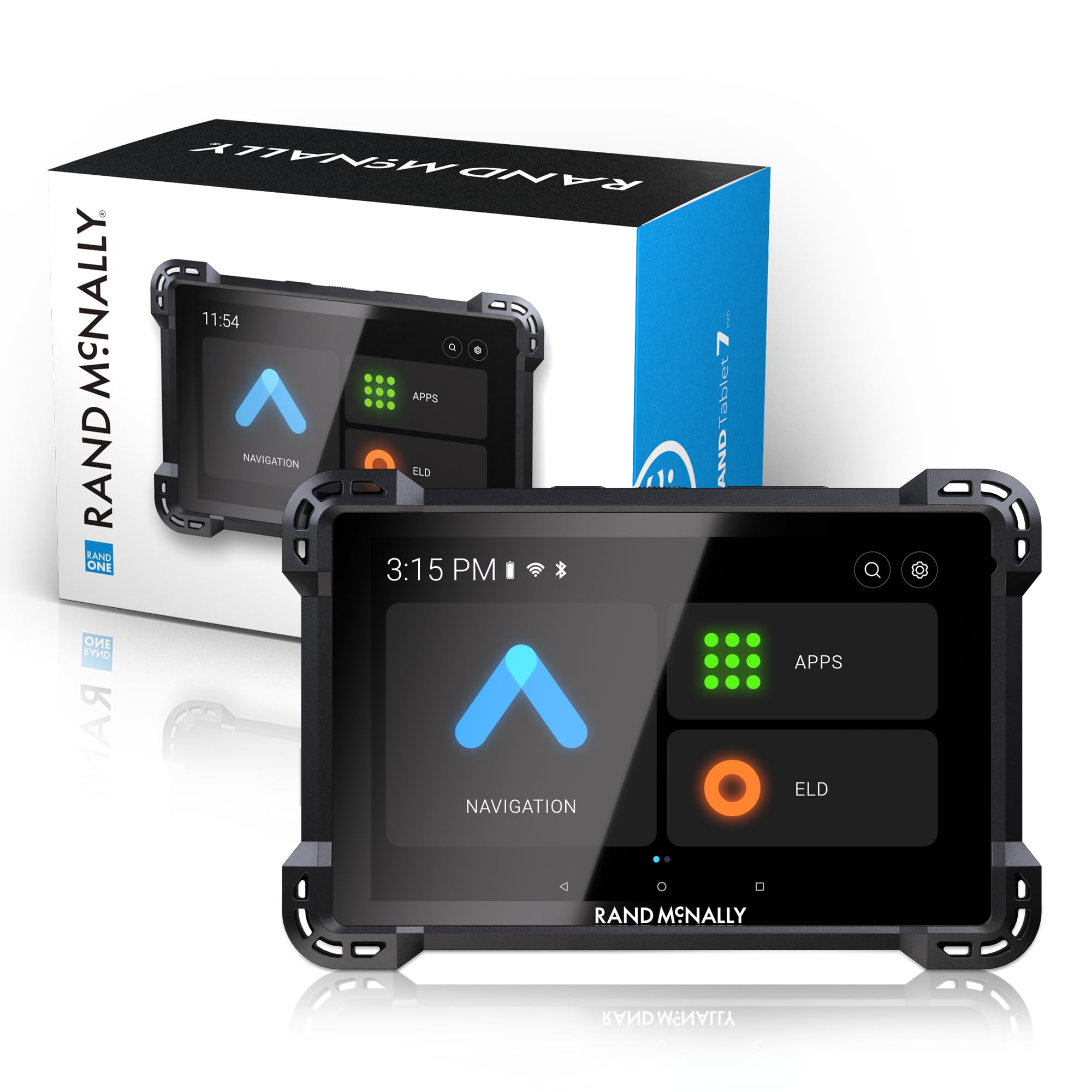
The Rand McNally RANDTAB7 combines a full 8-inch touchscreen with their latest Rand Navigation 2.0 software and 2025-edition maps, offering customizable truck-specific routing for height, weight, width, and all HazMat types. The device warns of weigh stations, sharp curves, narrow roads, and speed limit changes specific to truck routes.
The powered magnetic mount is robust, and the display remains cool even during long summer drives, preventing overheating shutdowns.
However, some users report that the device can lose GPS signal under clear skies, causing the truck icon to grey out and the unit to reboot to the main menu. Battery drain while plugged in is another complaint, and some addresses in the northeast are not found in the database, requiring cross-checking with a second device.
Why it’s great
- Full truck routing with HazMat support
- Built-in fuel entry and state mileage tracking
- Large 8-inch touchscreen stays cool in direct sun
Good to know
- GPS signal can drop unexpectedly on highways
- Battery drains slowly even when plugged in
- Address database has gaps in some regions
7. Garmin dezl OTR1010

The Garmin dezl OTR1010 is the ultimate large-screen truck navigator, featuring a 10-inch touchscreen that can be viewed in landscape or portrait orientation. The extra display real estate allows for a split-screen view showing your active map alongside an overview of the remaining route and impending weather conditions — useful for long hauls through changing terrain.
Custom truck routing covers the full North America map set including the US, Mexico, Canada, and various islands, with alerts for bridge heights, weight limits, sharp curves, and steep grades. The BirdsEye satellite imagery helps you preview loading docks and tight turns before arrival, reducing the risk of getting stuck.
The powered magnetic mount is one of the most secure in the industry, keeping the unit firmly in place even on rough washboard roads. Users consistently report that this GPS pays for itself by avoiding low bridges and restricted roads. The unit also supports backup cameras and the dēzl headset for a complete hands-free setup.
Why it’s great
- Massive 10-inch screen with landscape/portrait mode
- Split-screen view shows route overview and weather
- Rock-solid powered magnetic mount
Good to know
- Very bulky for smaller vehicles
- Cross-checking with Google Maps sometimes needed
- Requires app for live traffic and weather
8. Bushnell BackTrack Mini

The Bushnell BackTrack Mini is the entry-level option for off-roaders who mainly need a waypoint return function — mark your trailhead or camp, then navigate back without worrying about cell service. Its compact size and rugged waterproof construction make it easy to stash in a pack or attach via the included carabiner.
Battery life claims up to 35 hours on a single Micro USB charge, which is decent for weekend trips. The display is easy to read, and the large, glove-friendly buttons are a thoughtful touch for cold-weather use. It also shows elevation gain, barometric pressure, and sunrise/sunset times.
However, the user experience is mixed. The Bluetooth-connected app has significant compatibility issues — some users report that their S22 Ultra cannot download track data from the device, rendering the app essentially useless for trip review. The buttons are functional but small, and the 65-page manual hidden on the website is nearly mandatory to operate the device correctly.
Why it’s great
- Very affordable entry price for GPS navigation
- Compact and waterproof design
- Glove-friendly buttons and long battery life
Good to know
- Bluetooth app is unreliable for data sync
- Requires extensive manual reading to use
- Distance tracking can overestimate by up to 60%
9. Rand McNally RANDTAB6
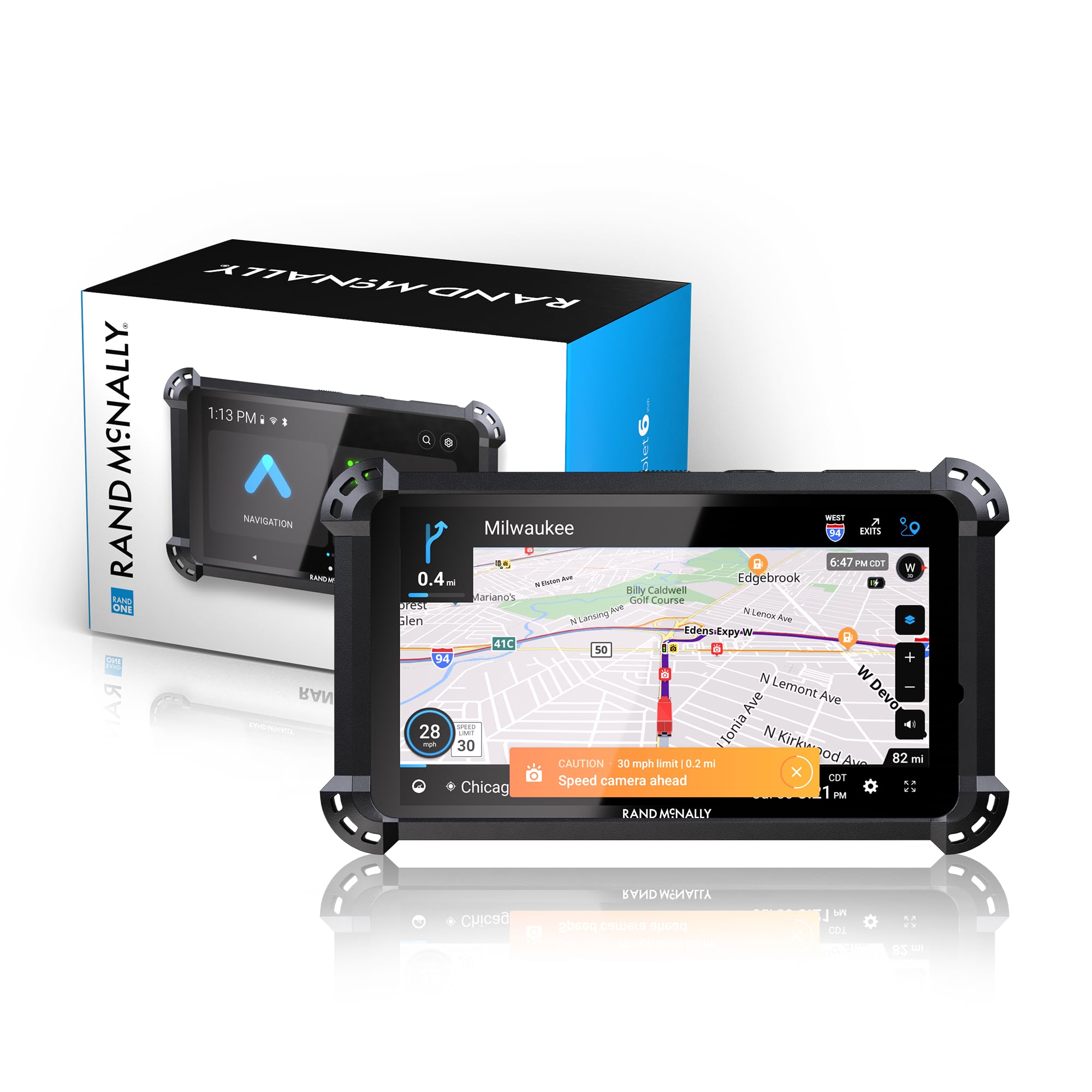
The Rand McNally RANDTAB6 brings tailored truck navigation to a smaller 6-inch form factor at a budget-friendly entry point for professional drivers. Powered by Rand Road IQ, it customizes routes based on truck dimensions and load specifics including HazMat types, trailer configurations, and axle count.
The display is clear and easy to read in sunlight, and the powered mount with both USB-C and barrel connectors ensures reliable power delivery. Built-in state mileage tracking and fuel entry support IFTA filing, making it a practical tool beyond simple navigation.
Common complaints include a constant 5 mph over speed limit warning that cannot be disabled, a mount that fails on rough roads, and missing roads in certain regions — particularly in the northeast. Several users report that the device frequently loses GPS signal on clear highways, causing the trip to reset and requiring manual re-routing. Battery drain while plugged in is also a noted issue.
Why it’s great
- Truck-specific routing for height, weight, and load
- State mileage tracking for IFTA compliance
- Clear sunlight-readable touchscreen
Good to know
- GPS signal drops frequently under clear skies
- Mount is not reliable on rough roads
- Address database has significant gaps in some regions
FAQ
How accurate are handheld GPS units under forest canopy?
Can I use a truck GPS for off-road trail driving?
Final Thoughts: The Verdict
For most users, the gps for off-road trails winner is the Garmin GPSMAP 67 because it combines multi-band GNSS accuracy with exceptional battery life and a rugged buttons-only interface that works in any weather. If you want a more budget-friendly device with AA battery flexibility, grab the Garmin GPSMAP 65. And for compact pocket-sized navigation on day hikes, nothing beats the Garmin eTrex 32x.