Nothing ends an RV trip faster than a low bridge or a road that bans RVs entirely. Standard car GPS apps don’t know your rig is 13 feet tall and 40 feet long. Without a purpose-built navigator, you’re relying on luck to keep your roof intact and your route legal. The right device bases every turn on your exact height, weight, and length — and it’s the single most important tool you can add to your dashboard.
I’m Mohammad Maruf — the founder and writer behind Drink4Good. I’ve spent years analyzing hardware specifications for the overland and RV community, comparing satellite acquisition speeds, map update policies, and routing algorithms to find what actually keeps RVers on safe roads.
Whether you drive a Class A motorhome, a fifth-wheel trailer, or a sprinter van conversion, this breakdown of the gps for rvers market will show you exactly where to invest your money for years of worry-free travel.
How To Choose The Best GPS For RVers
An RV navigator is a safety device first and a convenience tool second. The wrong pick can send a 40-foot rig down a road with a 12-foot clearance or a 10-ton weight limit. Focus on these four pillars to get it right the first time.
Custom Vehicle Profiling
This is the non-negotiable feature. Your GPS must let you enter your RV’s height, length, width, and weight, then use those numbers to block every road that can’t accommodate your rig. Some models also accept propane tank restrictions, axle count, and hazmat load types. Never consider a unit without full custom profiling.
Screen Size and Sunlight Readability
A 5-inch screen that washes out in midday sun is dangerous. Look for 7-inch or larger displays with high nits brightness and anti-glare glass or TFT panels. The most readable models maintain contrast even in direct sunlight, and they allow you to glance at the map without leaning forward or squinting.
Map Update Policy
Roads change — new construction, altered bridge heights, rerouted truck corridors. A device with free lifetime map updates saves you hundreds over the life of the unit. Those that require an annual subscription or offer only a single update window will eventually become a liability. Wi-Fi-enabled updates are a major convenience.
Live Traffic and Weather Integration
An RV takes longer to detour. Real-time traffic rerouting through a connected smartphone app or built-in receiver helps you avoid construction zones and accidents before you’re stuck in them. Weather overlays showing wind speed and precipitation along your route let you plan safe stops rather than pushing through dangerous conditions.
Quick Comparison
On smaller screens, swipe sideways to see the full table.
| Model | Category | Best For | Key Spec | Amazon |
|---|---|---|---|---|
| Garmin RV 770 | Touchscreen | RV-specific routing with hands-free | 6.95″ edge-to-edge display | Amazon |
| Garmin dezl OTR1010 | Large Screen | Maximum visibility and split-screen weather | 10″ touchscreen landscape portrait | Amazon |
| Garmin dezl OTR610 | Truck Routing | Professional driver-level truck routing | 6″ high-res multi-touch | Amazon |
| TomTom Go Camper Max | Camper Special | European RVing with campsite database | 7″ touchscreen 400G | Amazon |
| Rand McNally RANDTAB8 | 8-inch Tablet | Large display and built-in camera | 8″ LCD 2025 maps | Amazon |
| Garmin Camper 795 | 7-inch | Motorhome and caravan users | 7″ 1024×600 LCD | Amazon |
| Rand McNally RANDTAB7 | 7-inch Tablet | Hazmat and complex load specs | 7″ LCD 2025 maps | Amazon |
| Rand McNally TND 750 | Bundled Cam | Value pick with built-in dash cam | 7″ LCD touchscreen | Amazon |
| Garmin eTrex 32x | Handheld | Off-grid hiking and backup navigation | 2.2″ sunlight-readable | Amazon |
In‑Depth Reviews
1. Garmin RV 770

The Garmin RV 770 is the reference standard for RV-specific navigation. Its 6.95-inch edge-to-edge glass display delivers crisp readable directions even under harsh midday glare. After entering your RV’s height, length, width, and weight, the device automatically filters out roads with clearance or weight restrictions, saving you from discovery zones that would end your trip.
Hands-free calling and voice-activated navigation work reliably when paired with your smartphone, and the free Smartphone Link app feeds live traffic and basic weather directly to the unit. Built-in Wi-Fi means you can download map updates without connecting to a computer — a massive time saver when you’re on the road for months at a time.
The RV 770 also includes a substantial database of RV parks and services. Users report that the custom routing handles both motorhomes and towable trailers with equal accuracy, and the dedicated external speaker ensures clear audio prompts without cutting into your vehicle’s stereo.
Why it’s great
- Large high-res display readable in direct sunlight
- Free lifetime map updates via built-in Wi-Fi
- Custom vehicle profiling for height, weight, length, and propane
Good to know
- Battery life is around 1 hour, requires constant power
- Initial Wi-Fi setup can be finicky before first software update
2. Garmin dezl OTR1010

The Garmin dezl OTR1010 is the largest dedicated navigator in this roundup, sporting a 10-inch touchscreen that can be switched between landscape and portrait orientation. That extra real estate pays off when you use the split-screen mode to view your remaining route alongside impending wind and weather conditions — a feature that matters when you’re piloting a tall rig through crosswinds.
Custom truck routing covers every dimension and weight parameter you can enter. The device alerts you to upcoming bridge heights, weight limits, sharp curves, steep grades, and more. BirdsEye satellite imagery provides high-resolution aerial views of loading docks or campground entrances before you arrive, eliminating guesswork on tight approaches.
The powered magnetic mount is a standout design choice. It holds the unit securely on rough roads and allows quick removal for handheld use or security. PrePass weigh station notifications, a truck stop directory filterable by brand and amenity, and integration with the dezl smartphone app for live traffic and weather round out the package.
Why it’s great
- Massive 10-inch screen with orientation flexibility
- Split-screen weather and route overview
- Powered magnetic mount for security and convenience
Good to know
- May need cross-checking with phone GPS in rapidly changing construction zones
- Bulkier than smaller units, takes up significant dash space
3. Garmin dezl OTR610

The Garmin dezl OTR610 packs professional-grade truck routing into a 6-inch form factor that fits well on smaller dashboards or in rigs where screen real estate is tight. Its high-resolution multi-touch glass display remains crisp and readable even with the sun flooding the cab. The routing engine accounts for vehicle size and weight and delivers audible alerts for bridge heights, weight limits, sharp curves, and steep grades.
BirdsEye satellite imagery provides aerial views of your destination before you commit to a turn. The route planner lets you review the full trip and mark optimal stops for fuel, rest breaks, and overnight parking. A built-in truck and trailer services directory allows filtering by brand or amenity like showers or parking.
When paired with the dezl smartphone app, the OTR610 gains live traffic, weather, and loyalty program integrations with Love’s and Pilot Travel Centers. Users consistently praise the fact that the zoom level stays locked across routes — unlike some competitors that reset after every turn.
Why it’s great
- Bright high-resolution display with excellent sunlight readability
- Accurate truck routing with consistent zoom retention
- Loyalty program integration for fuel stops
Good to know
- Screen smaller than premium siblings, less split-screen capability
- Some users report Wi-Fi connectivity frustration for satellite downloads
4. TomTom Go Camper Max

The TomTom Go Camper Max is engineered specifically for campervan and motorhome use, making it an excellent companion for European RV travel. Its 7-inch touchscreen display is sharp and customizable. The standout here is the 12-hour battery life — far exceeding every other unit in this roundup — which means you can walk around a campground or plan your next day without staying tethered to the power outlet.
You enter your vehicle’s dimensions and axle load, and the TomTom builds routes that avoid low bridges, narrow lanes, and weight-restricted roads. The campsite database includes listings from ACSI, NKC Campercontact, Trailer’s Park, and iOverlander, giving you thousands of verified POIs for overnight stops. Traffic information is delivered via Wi-Fi, leaving Bluetooth free for music and phone calls.
Voice control works reliably once you’ve practiced the commands, and the traffic assistant shows delay causes and alternative detour times. The magnetic mount is minimal and blocks very little windshield view. Some users note the device is expensive, but the combination of 12-hour runtime and deep campsite integration justifies the premium for frequent European campers.
Why it’s great
- Exceptional 12-hour battery life for off-power use
- Extensive built-in campsite database from multiple providers
- Customizable display with clear traffic delay details
Good to know
- Primarily optimized for European maps and campground data
- Voice control requires practice to master
5. Rand McNally RANDTAB8
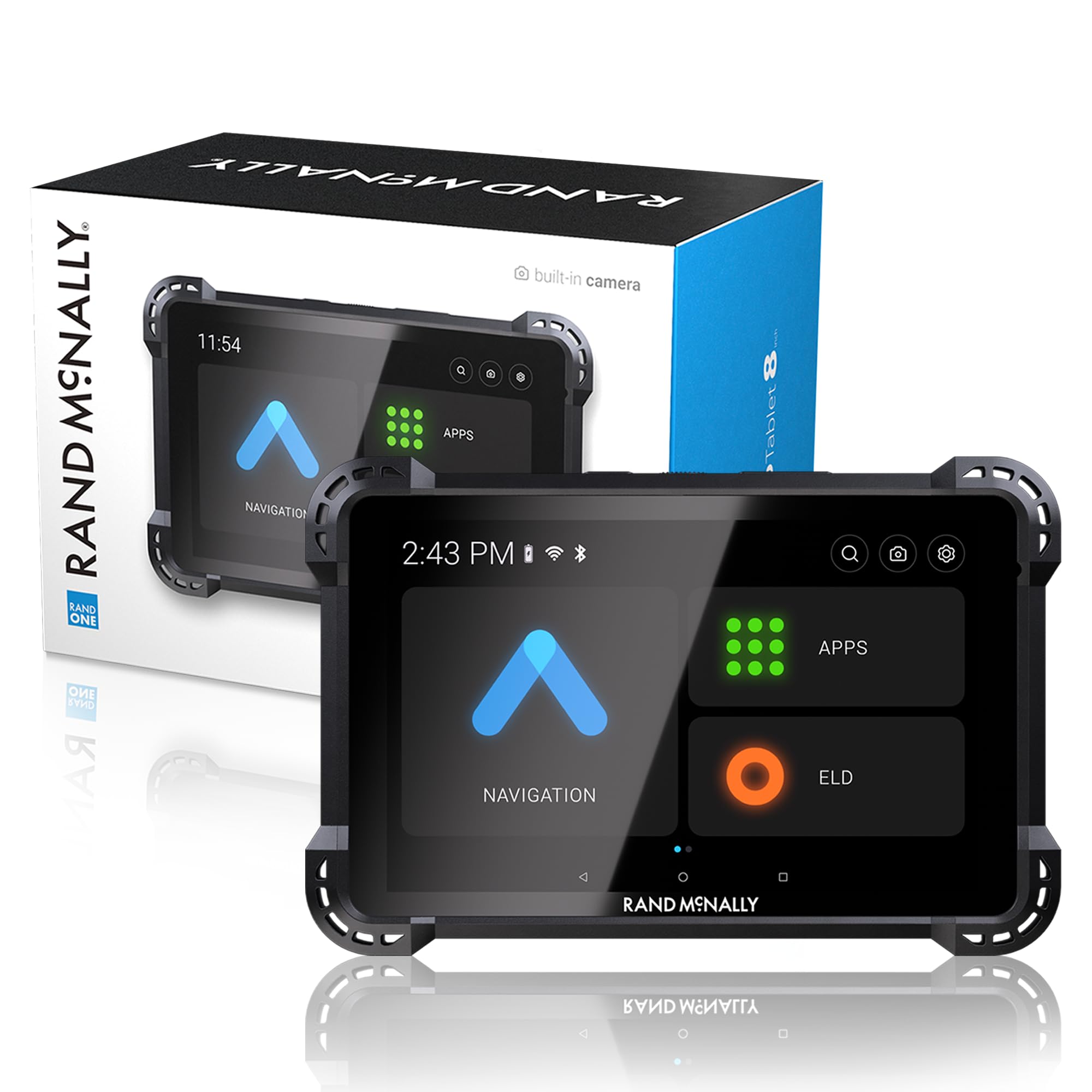
The Rand McNally RANDTAB8 offers the largest screen in the Rand lineup at 8 inches, combined with a built-in camera for image capture along your route. Powered by Rand Navigation 2.0 with 2025 edition maps, it uses Rand Road IQ to keep your rig on roads that match your dimensions and load specifications. The customization options go deep: you can configure weight, height, width, all hazmat types, trailer types including 48-foot, 53-foot double and triple, and axle counts from 2 to 15.
Real-time traffic, weather, fuel price comparisons, and speed camera alerts are all integrated. The device warns you about weigh stations, curves, hills, engine brake restrictions, narrow roads, and construction zones. The powered magnetic mount is reinforced for heavy use, and the device supports both USB-C and barrel power connections.
User feedback highlights the clear display and easy programming. However, some professional drivers report that on rough roads the mount can lose grip after several months, and the GPS signal occasionally drops under clear skies on major highways. It’s a powerful feature set, but reliability concerns mean it may not suit drivers who need absolute consistency every mile.
Why it’s great
- 8-inch LCD with excellent sunlight readability
- Highly granular load and trailer customization
- Built-in camera and 2025 map data included
Good to know
- Some units experience GPS signal loss and menu resets
- Mount can loosen on severely rough roads over time
6. Garmin Camper 795

The Garmin Camper 795 is purpose-built for motorhome and caravan users who travel Europe and South Africa. Its 7-inch color touchscreen delivers crisp 1024×600 resolution, and the device creates custom profiles for your camper, caravan, or trailer based on dimensions and weight. It shows environmental zones along the route — critical information for navigating low-emission areas in European cities.
The pre-installed 3D maps cover Europe and South Africa, with free updates available via Wi-Fi and Garmin Express. An integrated Michelin Green Guide provides pictures, descriptions, and reviews to help you decide if a landmark is worth visiting. The campsite database from ACSI, NKC Campercontact, Trailer’s Park, and iOverlander gives you thousands of options for overnight parking.
Birdseye satellite imagery aids arrival planning with clear aerial views of campgrounds and parking areas. Live traffic via DAB radio signal provides real-time rerouting without needing a smartphone. Driver warnings include sharp curves, steep grades, crosswinds, and more. The one-hour battery life requires constant cabin power, and some international users note that map downloading for non-European regions can be complex.
Why it’s great
- Pre-loaded 3D maps for Europe and South Africa
- Extensive campsite database from multiple providers
- Live DAB traffic without smartphone tethering
Good to know
- Battery life is very limited at 1 hour
- Some users report hardware failures within the first year
7. Rand McNally RANDTAB7
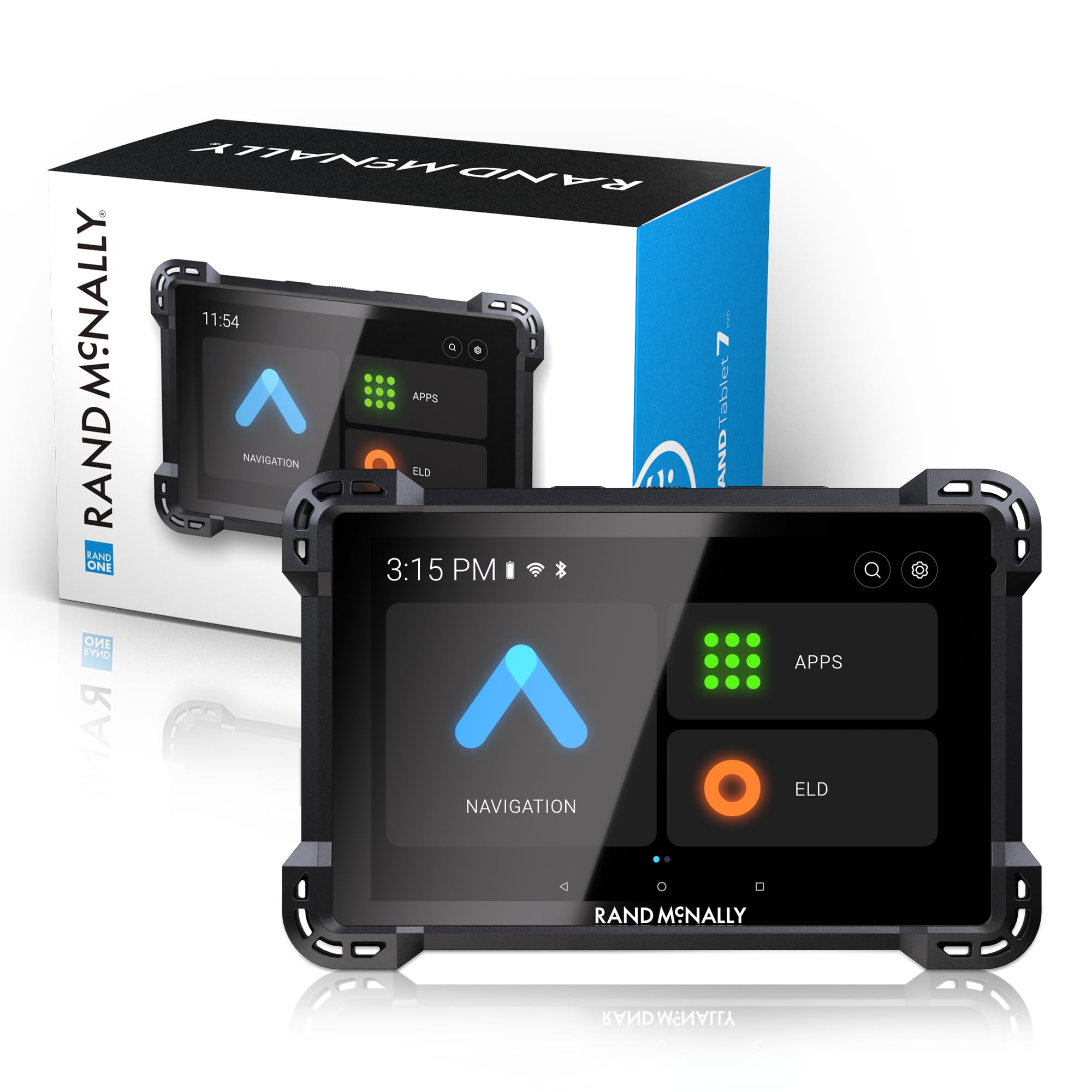
The Rand McNally RANDTAB7 brings the same Rand Navigation 2.0 software and 2025 maps as its 8-inch sibling but in a slightly smaller 7-inch package that’s easier to position on crowded dashboards. The custom routing engine handles every hazmat type including gases, explosives, flammables, and oxidizers, plus trailer configurations from straight to triple-axle combinations.
The device includes a built-in camera for image capture and a powerful magnetic mount sized for professional use. USB-C and barrel power connections provide redundancy if one cable fails on the road. Warnings cover weigh stations, curves, hills, engine brake restrictions, narrow roads, construction zones, speed limit changes, and red light and speed cameras.
While the initial user experience is positive — clear display, easy programming — there are recurring complaints about GPS signal loss under clear skies on major highways. Some drivers report the mount fails on rough roads after several months, and the address search occasionally returns no results for existing locations. The feature set is compelling for hazmat haulers, but reliability varies between units.
Why it’s great
- Comprehensive hazmat and trailer configuration options
- Dual power connection for reliability
- 2025 maps included, clear LCD display
Good to know
- GPS signal can drop unexpectedly on open highways
- Route calculation is inflexible with limited alternative suggestions
8. Rand McNally TND 750

The Rand McNally TND 750 is a sixth-generation truck GPS that bundles a built-in dash cam directly into the navigation unit. This means you get navigation and continuous video recording from a single device mounted on your windshield — a space-saving advantage for RVers who want incident documentation without another gadget on the glass. The 7-inch LCD touchscreen is readable from a typical driving position.
Custom truck routing allows you to profile your rig by size, weight, cargo type, and hazmat restrictions. Dynamic weather overlays show precipitation, temperature, and wind speed across your route. 3D buildings and landmarks help orient you in unfamiliar cities. Bluetooth connectivity supports hands-free calling and lane assist guidance.
The magnetic suction mount is easy to remove for security. Some users note the device required a 6GB Wi-Fi map update immediately after unboxing, with several reboots during the process. A small number of units have stopped functioning entirely within the first month, and some shipping incidents involve incorrect power cords. When it works, the TND 750 is a capable navigator with the added value of integrated dash cam recording.
Why it’s great
- Built-in dash cam eliminates the need for a separate device
- Dynamic weather overlays show conditions along the route
- Customizable for truck size, weight, cargo, and hazmat
Good to know
- Large initial map update required before first use
- Some units have reported complete failure within the first month
9. Garmin eTrex 32x

The Garmin eTrex 32x is not an RV dashboard navigator — it’s a rugged handheld GPS that serves as a backup or companion for off-grid navigation. With a 2.2-inch sunlight-readable color display and 25-hour battery life from two AA batteries, it’s the device you grab when you leave the cab to scout a trail, hike to a vista, or mark a waypoint far from the road. Its physical button interface works perfectly with gloves in cold weather.
The 32x adds a 3-axis compass and barometric altimeter over the base model, making it useful for elevation tracking and orienteering. It supports GPS and GLONASS satellite systems for improved tracking in canyons or dense forest. Preloaded Topo Active maps include routable roads and trails for hiking and cycling. Internal memory sits at 8 GB with a microSD card slot for additional map downloads.
This is not a primary navigator for a 40-foot motorhome. It lacks custom RV routing, bridge clearance alerts, and turn-by-turn voice guidance for highways. But as a trail-tested backup that can mark your RV’s parking spot and guide you back through unfamiliar terrain, it’s an invaluable companion for RVers who spend time outside the cab.
Why it’s great
- Exceptional 25-hour battery life on two AA batteries
- Physical button operation works with gloves
- 3-axis compass and barometric altimeter included
Good to know
- Small screen not suitable for in-cab highway navigation
- No custom RV routing or bridge height alerts
FAQ
Can I use a standard car GPS in my RV?
How often should I update the maps on my RV GPS?
Final Thoughts: The Verdict
For most users, the gps for rvers winner is the Garmin RV 770 because it balances a large sunlight-readable display, comprehensive custom vehicle profiling, and free lifetime map updates at a mid-range price. If you want the absolute largest screen with split-screen weather and wind overlays for heavy-weather confidence, grab the Garmin dezl OTR1010. And for European campers who need a 12-hour battery and deep campsite database integration, nothing beats the TomTom Go Camper Max.