A dead phone battery and a fork in the trail is the wrong time to discover your navigation plan has a hole in it. Dedicated GPS handheld devices solve this by offering reliable satellite locks, long battery endurance, and physical buttons that work in rain, cold, or when your fingers are numb. These units are purpose-built for environments where a smartphone is a liability, not a tool.
I’m Mohammad Maruf — the founder and writer behind Drink4Good. I analyze hardware specifications and market data daily, focusing on the durability, signal accuracy, and battery performance that define reliable GPS handhelds for backcountry use.
Whether you are a hiker, hunter, or overlander, the right handheld GPS can separate a confident return from a stressful ordeal. This guide breaks down the key specs and top models to help you find the best gps handheld devices for your specific outdoor needs.
How To Choose The Best GPS Handheld Devices
Choosing a GPS handheld is about matching the unit’s navigation capabilities to your terrain and activity. A day hiker on marked trails needs a simpler device than a backcountry explorer who relies on two-way satellite messaging. Focus on three factors to narrow your options.
Satellite Support and Antenna Type
Dual-frequency multi-band receivers, such as those found on the Garmin GPSMAP 65, lock onto signals faster and maintain accuracy in dense forests or deep canyons. Units with quad-helix antennas provide better signal reception than patch antennas when the device is tilted or in your pocket. For most users, multi-band support is the single most impactful spec for real-world accuracy.
Mapping and Navigation
Devices range from basic coordinate trackers with no built-in maps to full-featured units with preloaded TopoActive maps and routable trails. If you plan to follow specific trails, a unit with preloaded topo maps saves setup time. If you primarily use a compass and paper map as your primary navigation, a simpler unit that records waypoints and returns you to a start point may suffice.
Battery Life and Power Source
Expect 16 to 35 hours of battery life in standard GPS mode, with expedition modes on premium units extending that significantly. Some devices use standard AA batteries for easy field replacement, while others rely on internal rechargeable lithium-ion packs. For multi-day trips without resupply, AA-compatible models offer a distinct advantage.
Quick Comparison
On smaller screens, swipe sideways to see the full table.
| Model | Category | Best For | Key Spec | Amazon |
|---|---|---|---|---|
| Garmin GPSMAP 66i | Premium | Backcountry safety & navigation | 35 hr battery (10-min tracking) | Amazon |
| Garmin GPSMAP 65 | Premium | Multi-band accuracy in cover | Multi-band GNSS support | Amazon |
| Garmin Montana 680 | Premium | Large touchscreen & camera | 4″ sunlight-readable display | Amazon |
| Garmin GPSMAP 86i | Premium | Marine & floating use | Floating design + inReach | Amazon |
| Garmin GPSMAP 64sx | Mid-Range | Rugged hiking with altimeter | Quad-helix antenna | Amazon |
| Spot X | Mid-Range | Satellite messaging on budget | 2-way satellite messenger | Amazon |
| Bushnell BackTrack Mini | Budget | Simple return-to-start navigation | 35 hr battery life | Amazon |
| Bushnell BackTrack | Budget | Basic location marking | SiRF Star III receiver | Amazon |
| NiesahYan A6 | Budget | Coordinate tracking for hiking | 20 hr rechargeable battery | Amazon |
In‑Depth Reviews
1. Garmin GPSMAP 66i

The GPSMAP 66i is the gold standard for backcountry navigation because it merges a full-featured GPS with a satellite communicator in one rugged package. Preloaded TopoActive maps and direct-to-device Birdseye satellite imagery give you detailed terrain context, while the 3-inch sunlight-readable display ensures you can read it in bright conditions. Multi-GNSS support and a 3-axis compass with barometric altimeter provide accurate positioning even in steep, forested terrain.
Battery life is a standout at up to 35 hours in 10-minute tracking mode, and the 200-hour expedition mode extends that for multi-week trips. The inReach satellite technology allows you to send and receive text messages and trigger an interactive SOS to the GEOS 24/7 monitoring center. This device replaces the need to carry both a GPS and a separate satellite messenger.
The user interface has a learning curve, and a satellite subscription is required for messaging and weather features. The base price is premium, but the integrated functionality and reliable performance in remote areas make it the most capable all-in-one solution tested for serious adventurers.
Why it’s great
- Integrated inReach for SOS and two-way messaging
- Outstanding battery life in expedition mode
- Excellent satellite lock in difficult conditions
Good to know
- UI has a steep learning curve
- Requires a satellite subscription for messaging
- Premium price point
2. Garmin GPSMAP 65

The GPSMAP 65 is built around multi-band technology that receives both L1 and L5 frequencies across GPS, GLONASS, and Galileo. This dual-frequency approach allows the device to maintain accuracy within about six feet, even in dense tree cover or urban canyons where single-frequency units struggle. The 2.6-inch sunlight-readable color display and physical button operation make it reliable in wet or cold conditions where a touchscreen would fail.
Preloaded TopoActive maps with routable roads and trails cover the U.S. and Australia, and the device supports microSD cards for additional map storage. Battery life is rated at 16 hours in GPS mode, but real-world testing with NiMH rechargeable AAs showed up to 27 hours using battery save mode. The ability to use standard AA batteries is a huge plus for multi-day trips where power resupply is uncertain.
The Garmin Explore app integration requires a compatible smartphone and has been reported as buggy by some users. The default map detail level can appear low on first use, and loading custom maps requires navigating BaseCamp software. For those who prioritize raw navigational accuracy and field-swappable batteries, this is a top choice.
Why it’s great
- Multi-band GNSS for exceptional accuracy
- Standard AA battery compatibility
- Sunlight-readable 2.6-inch display
Good to know
- Garmin apps and BaseCamp have a learning curve
- Default map detail may underwhelm initially
- No satellite communication capability
3. Garmin Montana 680

The Montana 680 differentiates itself with a large 4-inch touchscreen that is bright and responsive even in direct sunlight, making it the best choice for users who prioritize visual detail. It supports GPS and GLONASS with a WAAS-enabled high-sensitivity receiver that maintains lock in heavy cover and deep canyons. The included 8-megapixel camera with geotagging is a unique feature for documenting waypoints and trail conditions.
Battery life is rated at 16 hours, and the device comes with a rechargeable lithium-ion pack. The Montana 680 is preloaded with 250,000 geocaches and includes a 1-year Birdseye Satellite Imagery subscription. It works well for both pedestrian hiking and vehicle navigation, supporting turn-by-turn voice directions when mounted in a car or boat.
The touchscreen is less practical in heavy rain or when wearing thick gloves compared to button-operated models. The altimeter has been reported to show large variations in elevation readings, and the overall size makes it less pocket-friendly than the GPSMAP 65 or 66i. For users who want the biggest, brightest screen and appreciate the camera integration, this is a strong option.
Why it’s great
- Large 4-inch sunlight-readable touchscreen
- 8MP geotagging camera
- Works for both hiking and vehicle navigation
Good to know
- Touchscreen difficult with gloves in rain
- Altimeter may show elevation swings
- Bulkier than button-operated models
4. Garmin GPSMAP 86i

The GPSMAP 86i is purpose-built for marine environments, with a floating design and a water-resistant build that survives submersion. The 3-inch display is visible in sunlight, and button operation ensures reliable use when your hands are wet. It streams boat data from compatible chartplotters, giving you consolidated marine system information on a single handheld screen.
Like the 66i, it integrates inReach satellite communication for two-way text messaging and interactive SOS via the Iridium satellite network. Battery life reaches up to 50 hours in 10-minute tracking mode, and the device can also function as a remote control for Garmin autopilots and Fusion Marine products. Optional BlueChart G3 charts provide detailed marine cartography.
The screen is relatively small compared to dedicated marine touchscreen units, and users report that the user interface feels dated. The price is high, and the chart and satellite subscriptions add ongoing costs. For kayakers, small boat owners, and anglers who need a safety device that will not sink if dropped, the 86i is a specialized tool with no direct competitor.
Why it’s great
- Floats if dropped overboard
- Integrates marine data from chartplotters
- Reliable inReach communication for SOS
Good to know
- Small screen for a marine device
- Requires subscriptions for charts and satellite
- UI feels outdated
5. Garmin GPSMAP 64sx

The GPSMAP 64sx continues Garmin’s legacy of rugged handheld navigation with a quad-helix antenna that provides superior signal reception compared to patch antenna designs. It supports multi-GNSS (GPS, GLONASS, and Galileo) for faster satellite acquisition and improved accuracy. Preloaded TopoActive maps for the U.S. and Australia include routable roads and trails, making it ready to use out of the box for hiking and cycling.
The 2.6-inch sunlight-readable display and button operation are well-suited for all-weather use. The 3-axis compass with barometric altimeter provides accurate heading and elevation data. Battery life reaches up to 16 hours in GPS mode, and the device uses standard AA batteries, which is a practical advantage for extended trips.
The 64sx lacks internal memory for map updates, requiring a microSD card for storage expansion. The interface and BaseCamp software are consistent with other Garmin units but take time to master. This model is a solid, no-frills choice for hikers and backpackers who want Garmin reliability without the premium cost of satellite communication features.
Why it’s great
- Quad-helix antenna for strong signal lock
- AA battery compatibility for field swaps
- Preloaded TopoActive maps
Good to know
- No internal memory for map updates
- Learning curve for BaseCamp and UI
- No satellite communication
6. Spot X

The Spot X is a dedicated two-way satellite messenger that operates on the Globalstar satellite network, allowing you to send and receive text messages and trigger an SOS from virtually anywhere. The device has a physical QWERTY keypad for composing messages without a smartphone, and Bluetooth connectivity lets you sync with the Spot X app for a more familiar typing experience. It has its own dedicated US mobile number so friends and family can text you directly.
Battery life is outstanding in standby mode at up to 240 hours, though continuous two-way messaging will drain it faster. The SOS function connects to a 24/7 search and rescue monitoring center, and you can message back and forth to communicate the nature of your emergency. The Spot X is an affordable entry point into satellite communication compared to Garmin inReach devices.
Reliability issues have been reported, including slow message sending in areas with 5G interference and an accelerometer that pauses tracking during activities like paddling. The keypad and interface are serviceable but feel dated, and the device lacks built-in mapping — it is purely a communicator. For budget-conscious hikers and hunters who want satellite SOS and messaging, it is a functional option if you accept its quirks.
Why it’s great
- Dedicated satellite messenger at a lower price point
- Physical QWERTY keypad for direct messaging
- Long standby battery life (240 hours)
Good to know
- No built-in mapping or GPS navigation features
- Reliability issues with sending/receiving near 5G
- Slow, dated user interface
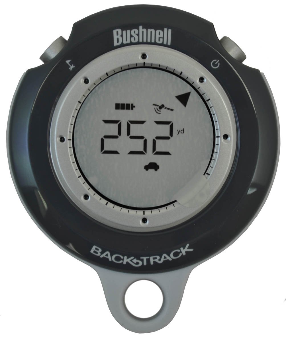
7. Bushnell BackTrack Mini

The Bushnell BackTrack Mini is a compact, waterproof GPS device designed for one primary job: guiding you back to your starting point. It captures your trailhead or basecamp location and shows direction and distance back to it, with elevation gain and barometric pressure data also available. The 35-hour battery life is exceptional for a device this size, and the rechargeable micro-USB battery means no expensive replacements.
Bluetooth connectivity allows you to sync trips and waypoints to the Bushnell Connect app on your smartphone for sharing and storage. The display is easy to read, and the large, glove-friendly buttons are a practical touch for cold-weather use. It also provides sunrise, sunset, moonrise, and moonset times for planning.
Some users report distance overestimation by up to 60% and elevation errors of over 200 feet. The quick-start guide is poor, and the full manual is hard to find online. The app has been criticized for being slow and sometimes failing to download data. As a simple backup to a map and compass, the BackTrack Mini works, but its accuracy limitations make it unsuitable for precise navigation in challenging terrain.
Why it’s great
- Excellent 35-hour rechargeable battery
- Compact, waterproof design for easy carry
- Glove-friendly buttons for cold conditions
Good to know
- Accuracy issues with distance and elevation readings
- Poor documentation and finicky app
- Limited to basic return-to-start navigation
8. Bushnell BackTrack Personal Locator
The original Bushnell BackTrack is the simplest device on this list — it stores up to three locations and provides distance and direction back to them using a high-sensitivity SiRF Star III GPS receiver. It is roughly the size of a large stopwatch, making it incredibly pocketable for day hikes, travel, or as a backup to find your parked car in an unfamiliar lot. The self-calibrating digital compass provides heading information when you are stationary.
Accuracy is typically within a few yards, and the device is weather-resistant for basic outdoor use. It runs on two AAA batteries, which are easy to replace and widely available. The interface is straightforward with minimal buttons, offering no navigation through menus or maps.
The direction arrow is known to be vague, requiring the user to walk a short distance to confirm the correct path. Satellite lock takes about a minute after moving to a new area. It offers no mapping, no elevation data, and no waypoint naming. For users who want an absolute minimum viable GPS for basic orientation, the BackTrack is a functional choice, but its capabilities are very limited compared to even entry-level modern units.
Why it’s great
- Extremely simple, pocketable design
- Stores up to three locations for basic navigation
- Runs on widely available AAA batteries
Good to know
- Direction arrow is vague, requires walking to confirm
- No mapping, elevation, or waypoint naming
- Satellite lock can be slow after moving far
9. NiesahYan A6 Handheld GPS

The NiesahYan A6 is a compact, rugged GPS handheld that supports four satellite systems (GPS, Galileo, BeiDou, and QZSS) for improved positional accuracy. The 2.4-inch sunlight-readable color display is bright and easy to follow, and the rechargeable battery provides up to 20 hours of continuous use via USB-C charging. It includes essential tools like a GPS compass and barometric altimeter, and it can record tracks and guide you back to your starting position.
The device is lightweight and has a heavy-duty case suitable for outdoor use. Satellite acquisition is reported as fast, and the screen stays locked under overhead tree cover. It stores waypoints along a track, allowing you to navigate back if you lose your direction.
This device has no built-in maps — it only provides coordinate navigation, a compass, and track recording. The menu navigation requires study and is not intuitive, and performance on steep, winding trails can reduce accuracy. It is not suitable for road navigation or map-based trip planning. For the budget-conscious hiker who understands the limitations and wants a basic coordinate tracker, the A6 is a functional entry point, but the lack of maps is a significant drawback for most users.
Why it’s great
- Fast satellite lock with multi-GNSS support
- Bright 2.4-inch sunlight-readable display
- Long 20-hour battery life with USB-C charging
Good to know
- No built-in maps, only coordinate navigation
- Menu system is unintuitive and requires study
- Accuracy degrades on steep, winding trails
FAQ
Can I use a GPS handheld without cell service?
What does multi-band GNSS mean for hiking accuracy?
Is a satellite messenger worth the extra subscription cost?
Final Thoughts: The Verdict
For most users, the best gps handheld devices winner is the Garmin GPSMAP 66i because it combines full-featured GPS navigation with integrated inReach satellite communication in a single, durable package. If you want multi-band accuracy and field-swappable AA batteries, grab the Garmin GPSMAP 65. And for a simple, budget-friendly backup that will not let you down on day hikes, the Bushnell BackTrack Mini is a solid choice.