A reliable GPS unit changes everything when you’re on the water. Whether you’re navigating a winding river, crossing a wide lake, or exploring a coastal marsh, losing your bearings isn’t just an inconvenience—it can be a genuine safety risk. A dedicated device designed for the outdoors offers features that a smartphone simply can’t match: waterproof ruggedness, sub-meter accuracy, and a battery that lasts for days, not hours.
I’m Mohammad Maruf — the founder and writer behind Drink4Good. My approach to these recommendations comes from months of market research, cross-referencing technical specifications against real-world paddling scenarios to find the units that will actually perform when water conditions get tough.
This guide will help you navigate the key specs and features that matter most for a day on the water, so you can confidently choose the right gps for paddling to keep your adventures on track and your mind at ease.
How To Choose The Best GPS For Paddling
Selecting a GPS for paddling involves more than just picking the most expensive option. You need a device that can survive a splash, hold a signal in remote areas, and provide clear navigation for hours on end. Here are the three most important factors to weigh before you buy.
Waterproofing and Ruggedness
The IPX7 rating is the baseline for any device you’d trust on a kayak or canoe. This means it can handle submersion in up to one meter of water for 30 minutes. For serious paddlers, units rated to IP68 or built to military standards offer far more protection against unexpected capsizes or heavy rain. A device with a durable, slip-resistant grip is also critical—wet hands can easily fumble a smooth plastic case.
Battery Life and Power Options
An eight-hour paddle is a standard day trip, but you should never cut your battery life that close. Look for a unit that offers a minimum of 20 hours in standard GPS mode. Devices that run on standard AA batteries are often preferred over built-in rechargeables, because you can carry spare batteries and restart a dead unit in seconds. Models with an expedition or power-save mode can stretch battery life to days, not hours.
Map Detail and Navigation Features
Not all GPS units come with built-in maps. Some entry-level models only record coordinates and let you track back to your starting point. For river paddling or coastal exploration, you want a device with preloaded topographic maps that show land contours, water depth edges, and road access points. A 3-axis compass and barometric altimeter are also valuable additions—they give you heading and elevation data even when you’re stationary, which helps you orient yourself in fog or low visibility.
Quick Comparison
On smaller screens, swipe sideways to see the full table.
| Model | Category | Best For | Key Spec | Amazon |
|---|---|---|---|---|
| Garmin Instinct 3 45mm | Premium Watch | All-day wear & solar charging | MIL-STD-810 / 10 ATM | Amazon |
| Humminbird Helix 5 Chirp G3 | Marine Chartplotter | Fishing & lake mapping | 5” color TFT display | Amazon |
| Garmin eTrex 32x | Rugged Handheld | Backwoods navigation & hunting | Topo Active maps preloaded | Amazon |
| SOUYIE Outdoor Smartwatch | Feature Watch | Multi-sport & offline maps | 1.43” AMOLED / 4GB storage | Amazon |
| Bushnell BackTrack Mini | Compact Tracker | Simple track-back navigation | 35 hour battery / Bluetooth | Amazon |
| NiesahYan 3.2” GPS | Budget Handheld | US topo maps on a budget | 36 hour battery / IP66 | Amazon |
| Nautilus LifeLine nexGen | Safety Beacon | Emergency DSC/AIS alert | AIS & DSC distress signal | Amazon |
| Garmin eTrex SE | Entry Handheld | Extended battery & geocaching | 168 hour battery (standard) | Amazon |
| NiesahYan A6 | Budget Tracker | Cost-effective coordinate tracking | 2.4” display / 20 hour battery | Amazon |
In‑Depth Reviews
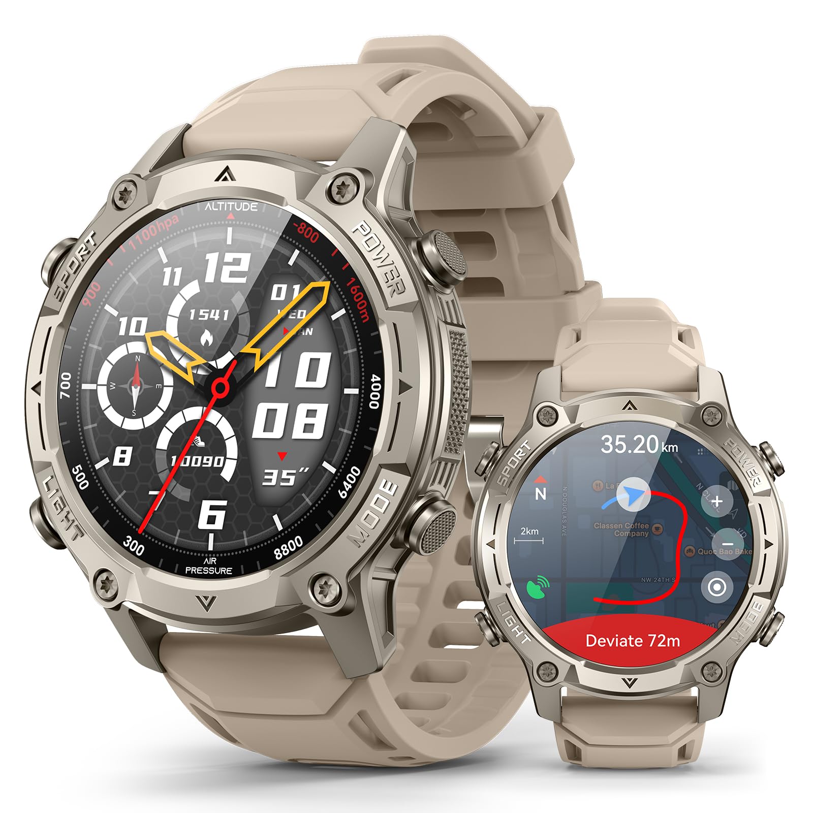
1. Garmin Instinct 3 45mm Solar

This is the pinnacle of rugged outdoor GPS watches, built to MIL-STD-810 standards and rated to 10 ATM (100 meters) of water resistance. The 45mm fiber-reinforced polymer case and metal-reinforced bezel shrug off impacts, while the solar charging lens can theoretically deliver unlimited battery life with enough daily sun exposure. For paddleboarders and kayakers, the multi-band GPS with SatIQ technology locks onto signals even under dense tree cover or between deep canyon walls, delivering sub-10-foot accuracy consistently.
The built-in LED flashlight with variable strobe modes is a standout safety feature for low-light river crossings or signaling. Health monitoring—wrist-based heart rate, Pulse Ox, and advanced sleep tracking—makes this a genuinely useful 24/7 device, not just a GPS you strap on for a paddle. The 1.2-inch MIP display is always on and readable in direct sunlight, which is a deal-breaker for many AMOLED smartwatches on the water.
You won’t get preloaded topographic maps or music playback—Garmin intentionally stripped those to maximize battery life and durability. But for pure navigation, 38 days of standard battery life (unlimited with solar), 10 ATM waterproofing, and a 3-axis compass you can trust while stationary make this the most versatile GPS for paddling on the market. It pairs seamlessly with the Garmin Explore app for trip planning, weather updates, and smart notifications.
Why it’s great
- Solar charging extends battery indefinitely on long expeditions
- 10 ATM water rating handles submersion, waves, and heavy rain
- Multi-band GPS and SatIQ maintain lock in difficult terrain
Good to know
- No preloaded topographic maps or music storage
- Smaller 1.2-inch screen compared to dedicated handheld units
2. Humminbird Helix 5 Chirp GPS G3

A dedicated marine chartplotter, the Helix 5 is in a different league from wearable or handheld GPS units. The 5-inch color TFT display gives you a clear, detailed view of Humminbird’s Basemap, which covers over 10,000 lakes and the continental U.S. coastlines. For paddlers who fish, the Dual Spectrum CHIRP sonar is a massive advantage—it scans directly under your hull for fish arches and structure in both wide and narrow modes, revealing drop-offs, weed lines, and submerged logs.
AutoChart Live is the feature that truly sets this apart: it records depth contours, bottom hardness, and vegetation in real time while you paddle. You can build your own high-definition map of any lake or river in eight hours of recording time. The keypad control system is a deliberate advantage over touchscreens here—gloved or wet hands won’t interfere with operation, and the soft keys are easy to find by feel when your focus is on the water ahead.
The transducer mount is designed for a transom installation, which works best on a kayak with a track system or a compact fishing boat. The unit is not fully submersible, but the display and housing are built for spray and rain. It’s a heavy 2.12-pound unit, so it’s best suited for a sit-on-top kayak or canoe with a dedicated mount, not for a small paddleboard.
Why it’s great
- Real-time depth contour mapping creates custom lake charts
- Large 5-inch display provides exceptional clarity for navigation
- Keypad controls work reliably with wet or gloved hands
Good to know
- Not waterproof for full submersion; requires careful mounting
- Heavy unit is best for larger kayaks, not lightweight SUPs
3. Garmin eTrex 32x

The eTrex 32x is the gold standard for backcountry navigation and easily adapts to paddling. It features a 2.2-inch sunlight-readable color TFT display and comes preloaded with Topo Active maps that include routable roads and trails, along with river and lake outlines. The addition of a 3-axis compass and barometric altimeter gives you heading and elevation data even while stationary, which is crucial when fog or low light obscures visual landmarks.
It supports both GPS and GLONASS satellite systems simultaneously, which improves lock speed and stability in steep ravines or dense forest along a river bank. Battery life is a strong 25 hours in GPS mode using two standard AA batteries. The ability to swap in fresh batteries from a dry bag is a massive advantage over devices with built-in rechargeable packs—you can keep navigating for a week straight without needing a power bank.
The 8GB of internal memory can hold additional maps, and the microSD card slot allows for virtually unlimited storage expansion. Some users report a learning curve with the menu interface, and the screen refresh lag is noticeable when scrolling across detailed map areas. But once you’re familiar with the button layout, the eTrex 32x becomes a reliable, accurate tool that performs exactly when you need it most.
Why it’s great
- Preloaded Topo Active maps cover North American waterways and trails
- AA battery operation allows instant power resupply in the field
- 3-axis compass and altimeter function without satellite lock
Good to know
- Menu system takes several trips to learn thoroughly
- Screen refresh can lag when panning across detailed map zones
4. SOUYIE Outdoor Smartwatch
This smartwatch brings a huge 1.43-inch AMOLED display (466×466 resolution, 1000 nits brightness) to the paddling market, plus standalone GPS that works without a phone connection. The 5ATM water rating allows for surface swimming and submersion down to 50 meters, making it fully suitable for kayaking, canoeing, and even surf zone paddling. The offline topographic maps are a standout feature—you can preload terrain detail and review it anywhere, even in areas with zero cellular signal.
The 550mAh battery delivers 10–21 days of regular use, and a 30-minute magnetic charge gives you 60 hours of power. The GPS tracking error is rated under 2.8%, which is solid for a wrist-based unit. Additional sensors include a barometer for altitude, a compass for orientation, and the HX3691 sensor for heart rate, SpO2, and stress monitoring. The 4GB onboard storage can hold music and voice recordings directly on the watch.
The zinc alloy case and Panda Glass screen are scratch-resistant, but the 5ATM rating means it’s not designed for deep diving or high-pressure water sports. The AMOLED display, while gorgeous, consumes more power than MIP displays in constant-on mode. For a budget-friendly option that packs almost every feature a paddler could want into a watch form factor, this device is hard to beat.
Why it’s great
- Bright AMOLED screen is readable even in direct sunlight
- Offline topographic maps and standalone GPS don’t require a phone
- Long battery life and rapid recharge support multi-day trips
Good to know
- AMOLED screen uses more power than MIP in always-on mode
- 5ATM rating is splash-proof but not for deep submersion
5. Bushnell BackTrack Mini

The BackTrack Mini is a refreshingly simple GPS tracker designed for one primary function: getting you back to your starting point. It uses GPS to capture your trip or waypoint as you paddle, and then guides you back to that position. The easy-to-read LCD display and large, glove-friendly buttons are deliberately simple—there’s no complex menu system to learn, no maps to download. For a day kayaker who just wants a safety net against getting disoriented on a big lake, this is an excellent choice.
The device is rugged and waterproof, with up to 35 hours of battery life on a single micro USB charge. It also provides elevation gain and decline data, barometric pressure, and sunrise/sunset times, which are useful for planning your paddle. Bluetooth connectivity lets you sync your trips and waypoints to the Bushnell Connect app for later review, but the app functionality has been reported as inconsistent by some users.
The major limitation is that it lacks any map display—it shows a compass bearing and arrow, not a map with your position plotted. Some users report that the distance tracking can overestimate actual distance by up to 60%, and the elevation data can be off by 200 feet or more. It’s a tool for directional assistance, not precise navigation. For paddlers who want a dedicated, distraction-free backup to their main navigation system, it fits that role perfectly.
Why it’s great
- Extremely simple operation with large, glove-friendly buttons
- Long 35-hour battery life for multi-day trips
- Compact and rugged design fits easily in a dry bag
Good to know
- No map display—shows only bearing and distance to waypoint
- Distance and elevation accuracy can be inconsistent
6. NiesahYan 3.2″ Handheld GPS

This unit is the most affordable way to get a GPS with preloaded USA topographic maps and a 3.2-inch sunlight-readable screen. The display is noticeably larger than most entry-level handhelds, which makes map-reading easier while paddling. It supports multiple GNSS constellations (GPS, Galileo, BeiDou, QZSS) for positional accuracy within six feet, and the IP66 water resistance rating protects against heavy spray and rain, though not full submersion.
The 36-hour rechargeable battery is excellent for its price tier, and the USB-C charging port is a welcome modern convenience. It comes with a 3-axis compass and barometric altimeter, so you can get heading and elevation data without relying on satellite lock. The 32GB of internal memory is generous for storing additional map data or GPX files.
Build quality and software reliability are concerns at this price point. Several user reports describe units failing after the first field test, entering boot loops, or exhibiting coordinate inaccuracies. The menu navigation can be confusing, and the documentation is sparse. For a paddler on a tight budget who needs a basic topographic map device, it can work—but be prepared for a learning curve and the possibility of a faulty unit.
Why it’s great
- Large 3.2-inch sunlight-readable screen ideal for map viewing
- Preloaded USA Topo maps and 32GB storage at a low cost
- 36-hour battery with USB-C charging is very convenient
Good to know
- Reliability concerns with some units failing early
- IP66 splash rating, not fully submersible
7. Nautilus LifeLine Marine Rescue GPS nexGen

This isn’t a general-purpose GPS—the Nautilus LifeLine is a dedicated marine rescue beacon that should be in every serious kayaker’s or paddleboarder’s safety kit. It transmits a digital distress signal over VHF radio waves, alerting both AIS-equipped vessels and VHF DSC radios within range. When activated, it broadcasts your GPS position with one-meter accuracy to every AIS receiver in the area, making you visible to nearby boat traffic in minutes.
The device is compact and lightweight at 4.6 ounces, and it’s depth-rated to 425 feet (130 meters) with the outer lid closed. The IP68 rating means it’s fully watertight even with the cap open, so it can survive a full submersion during a capsize. It requires two CR123A photo batteries (not included), and the battery life is rated for five years in standby mode. The MMSI programming process is done through a phone app with a light-flashing sequence, which can be fiddly but is manageable.
It’s important to understand what this device is not: it is not a navigation tool. It doesn’t show you a map, track your route, or display your current position in real time. It only transmits your location in an emergency. The antenna deployment tool is small and easy to lose, and the o-ring seals are a known weak point—you should inspect them before every trip. For open-water and coastal paddling, this is a life-saving complement to your primary GPS.
Why it’s great
- Broadcasts distress signal to all AIS/DSC vessels in range
- IP68 watertight and depth-rated to 425 feet
- Compact and lightweight enough to wear on a life vest
Good to know
- Not a navigation device—emergency distress only
- O-ring seals require regular inspection for integrity
8. Garmin eTrex SE

This is Garmin’s entry-level handheld, but it packs a battery life that beats almost everything else on this list. In standard GPS mode, the eTrex SE runs for up to 168 hours on two AA batteries. In expedition mode, that stretches to a staggering 1,800 hours—75 days of continuous tracking. For a multi-week river expedition or a long-distance paddling journey, this battery performance is unmatched.
The 2.2-inch sunlight-readable color display is clear and bright, though it lacks the detail of higher-end eTrex models. It supports multiple GNSS constellations (GPS, GLONASS, Galileo, BeiDou, QZSS) for reliable tracking in challenging environments, including deep tree cover and canyon rivers. It also pairs with the Garmin Explore app via Bluetooth, allowing wireless software updates, trip planning, Active Weather, and smart notifications.
There are notable trade-offs at this price: the eTrex SE does not come with preloaded topographic maps. You can load maps from a smartphone via the Explore app, but the device itself relies on basic track navigation. The menu navigation takes some getting used to, and the buttons require a deliberate press. Geocaching Live integration is a bonus for those who enjoy that hobby. It’s a solid entry-level choice for paddlers who prioritize battery longevity above all else.
Why it’s great
- 168-hour standard battery life—best in class for handhelds
- Wireless connectivity for trip planning and weather updates
- Multi-GNSS support improves lock speed and accuracy
Good to know
- No preloaded topographic maps included
- Button membrane feels stiff and requires deliberate pressure
9. NiesahYan A6 Handheld GPS

The A6 is the most affordable entry into GPS navigation for paddlers who simply want to record a track and follow it back. The compact and lightweight design features a 2.4-inch color LCD screen that remains readable in direct sunlight. It supports four satellite systems (GPS, Galileo, BeiDou, and QZSS) for reliable positioning, and the rechargeable battery provides up to 20 hours of continuous use. USB-C charging is a plus at this price point.
Its functionality is limited to basic track navigation: you can record a route as you paddle, store waypoints along it, and then follow the track back to your starting point. It includes a GPS compass for heading and a barometric altimeter, but it lacks any built-in maps. The screen displays your coordinates, heading, and a simple compass rose, but not a chart or map. A user describes it well: it functions as a coordinate tracker, not a true navigator.
The A6 has a rugged, waterproof case and a bright LED screen, but the lack of maps makes it unsuitable for exploring unfamiliar waterways without a paper chart or phone as backup. Menu navigation requires some study, and the accuracy on steep or winding terrain can suffer. For a paddler on a strict budget who only needs a reliable track-back device for familiar waters, this will do the job. Just be aware that it’s a very basic tool.
Why it’s great
- Lowest cost entry point for a dedicated GPS navigator
- 20-hour battery with USB-C charging is sufficient for day trips
- Compact and lightweight design fits easily in a dry bag
Good to know
- No maps are included—coordinates and compass only
- Accuracy degrades on steep, winding terrain
FAQ
Can I use a regular hiking GPS for kayaking or canoeing?
How accurate do I need my GPS to be on the water?
What is AIS and do I need it for paddling?
Is a GPS watch enough for serious paddling trips?
Final Thoughts: The Verdict
For most users, the gps for paddling winner is the Garmin Instinct 3 45mm Solar because it offers unmatched durability, battery life, and waterproofing in a versatile smartwatch format that works 24/7. If you want a dedicated marine chartplotter with real-time depth mapping for fishing, grab the Humminbird Helix 5 Chirp G3. And for a budget-friendly handheld with preloaded topographic maps, nothing beats the NiesahYan 3.2” GPS at its price point.